How Wind Flows Over Sand Dunes, in 3D

The force of wind blowing over the land can shape Earth's surface in profound ways, and now for the first time scientists have mapped in 3D how air flows over a large beach dune.
Novel 3D models of how wind blows could help reveal how coastlines might recover after major storms, such as Superstorm Sandy, the researchers say.
Similarly to the way a river flowing across Earth's surface directs where sediment gets deposited, coastal winds flowing over beach dunes influence how sand is transported along coastlines. Wind can dramatically help beaches and dunes rebuild themselves after erosion by coastal storms.
"Coastal dunes are of interest for many practical applications," said researcher Irene Delgado-Fernandez, a coastal geomorphologist at Edge Hill University in England. For instance, "coastal dunes are protective buffers against coastal erosion and flooding." Moreover, "coastal dunes are also the subject of numerous economic and recreational activities, such as tourism, sports [and] mining."
2D to 3D
Scientists have often explored the influence of wind on dunes, but most of this research was highly simplified. For example, analyses often treated dunes as two-dimensional objects, and typically concentrated on dunes with smooth slopes and no vegetation or other irregularities that could divide air currents flowing over them. [Earth Quiz: Mysteries of the Blue Marble]
"A main issue with 2D studies is that they do not take into account 3-dimensional variability," Delgado-Fernandez told OurAmazingPlanet.
Sign up for the Live Science daily newsletter now
Get the world’s most fascinating discoveries delivered straight to your inbox.
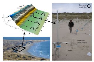
To get a better picture of the complex way air flows, Delgado-Fernandez and her colleagues deployed sensors that measure wind speed over the surface of a beach dune in Northern Ireland. The devices covered a grid about 200 feet (90 meters) alongshore and 200 feet (60 m) cross-shore.
"Our research involves working with a substantial amount of gear, including tens of sensors, hundreds of meters-long cables that need burying under the beach surface, and complex logging systems to communicate with the sensors and store the data," Delgado-Fernandez said. "It took a group of six people approximately four full days to complete the instrumental setup. Once everything was appropriately deployed and connected, we only needed to turn on the power, wait for the wind to blow in the correct direction, and enjoy the fun."
"Our trailer also served as the field headquarters during the experiment, where we could safely eat our sandwiches during the rainy Irish autumn," she added.
Over 10 days, the scientists monitored the complex way strong offshore winds flowed over the dune, enduring two storms to gather data.
"This is the first field study recording 3D wind data over a considerably large 3D beach-dune surface," Delgado-Fernandez said. And the study revealed valuable data.
"Probably one of the most exciting moments, the moment we felt we were onto something, was when we clearly quantified, over several hours, the movement of relatively large volumes of sand being delivered from the beach to the dune during offshore winds," Delgado-Fernandez added. "This was the first time the complexities of this particular process were measured in the field."
Complex picture
The scientists found that wind patterns across a given spot of the dune could vary greatly from those measured a few feet away, even under similar incoming wind. This differs substantially from 2D models of dunes, Delgado-Fernandez said.
"The presence of vegetation creates topographic differences and irregular shapes at the crest and dune slopes that complicate things significantly," Delgado-Fernandez said. "Irregular topographies strongly interfere with the wind and they significantly modify the wind's speed, direction and potential for sediment transport."
The scientists added there were gaps in their grid of sensors that kept them from capturing key data. They are now using computer modeling to predict where to best place sensors in the future to better analyze complex patterns of airflow.
In the future, the researchers hope to generate improved predictions of how coastal dunes will evolve over the course of months to years. These could help authorities manage coastlines better, Delgado-Fernandez said. A better understanding of how coastlines change is also valuable, given ongoing challenges posed by climate change, she added.
The scientists detailed their findings online Feb. 4 in the Journal of Geophysical Research-Earth Surface.
Follow OurAmazingPlanet @OAPlanet, Facebook and Google+.Original article at LiveScience's OurAmazingPlanet.

Most Popular

