Satellite Spies Pagan Island Volcano Plume

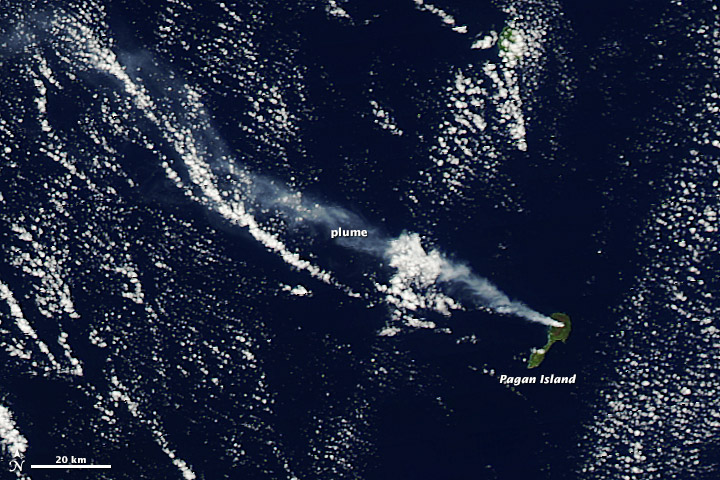
A plume of steam and volcanic gases emanated from the Pagan Island volcano in the northwest Pacific Ocean in this image taken by NASA's Aqua satellite on Oct. 16.
Pagan Island is part of the Mariana Islands archipelago, which lie to the south of Japan and just west of the Mariana Trench, where the deepest spot on Earth is found. The island is one of the largest and one of the most active volcanoes in the archipelago, according to the Smithsonian's Global Volcanism Program.
The island is actually made up of two stratovolcanoes, North and South Pagan. North Pagan's summit is 570 meters high and its caldera is 7 kilometers in diameter; South Pagan is a bit smaller, with a height of 548 m and a caldera diameter of 4 km, according to Smithsonian records.
Most of the eruptions on the island in historical times have come from North Pagan, including the largest known eruption, which happened in 1981 and led to the permanent evacuation of all 53 inhabitants of the island, according to NASA's Earth Observatory. The volcano's most recent eruption occurred in 2010, and the volcano has been active for more than three years.
Satellites are the only way scientists can observe the Pagan volcano as there are no ground-based instruments in place to detect any seismic rumblings from the island. The latest U.S. Geological Survey update on the volcano noted that there didn't seem to be any eruptive activity at the volcano currently.
Sign up for the Live Science daily newsletter now
Get the world’s most fascinating discoveries delivered straight to your inbox.


