Where Is the Literal 'Middle' of the Ocean?

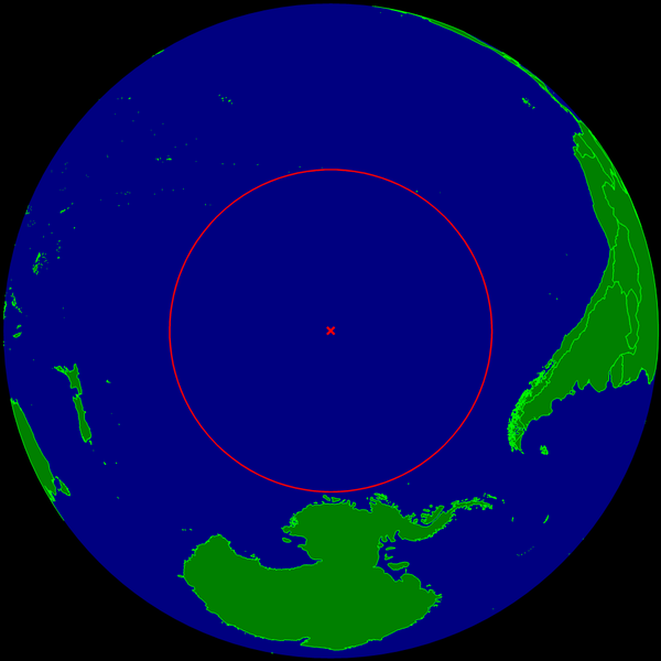
The farthest point from dry land floats exactly where you would expect: smack dab in the middle of the South Pacific. Called Point Nemo after the submarine captain in Jules Vernes classic novel, "Twenty Thousand Leagues Under the Sea," it marks the center of an empty blue circle about the size of North America. But how in the world was this spot found?
Considering all the islands that sprinkle Earth's seas, and the continent's chaotic coastlines, there was no conceivable way to locate the literal "middle of the ocean" until modern times, with the help of GPS satellites and computers.
In 1992, a Croatian-Canadian survey engineer named Hrvoje Lukatela used a geospatial program of his own design, called Hipparchus, to find Point Nemo. He did so by noting that because Earth's surface is three-dimensional, its remotest ocean point must sit the same distance away from three nearest coastlines; the Hipparchus program identified the ocean coordinate that was farthest from three other equidistant land coordinates.
Point Nemo, at coordinates 48°52.6′ south, 123°23.6′ west, lies 1,670 miles (2688 kilometers) from a trio of land dots: Ducie Island to the north, an uninhabited atoll in the Pitcairn Islands; Motu Nui to the northeast, a tiny islet off Easter Island, which is off the coast of Chile; and frigid Maher Island to the south, off the Antarctic coast.
According to Ken Jennings at The Daily Traveler, the word Nemo comes from the Latin for "nobody"; fitting, he said, as it's quite possible Point Nemo "has never had a single visitor."
Follow Life's Little Mysteries on Twitter @nattyover or Life's Little Mysteries @llmysteries. We're also on Facebook & Google+.
Sign up for the Live Science daily newsletter now
Get the world’s most fascinating discoveries delivered straight to your inbox.


