The Cassava Express: 1st Antarctica Atmospheric River Found

SAN FRANCISCO — A wild weather phenomenon that causes massive winter flooding in California also dumps snow in East Antarctica, wetting one of the driest places on Earth, researchers said here Thursday (Dec. 12) at the annual meeting of the American Geophysical Union
This is the first time scientists have spotted an atmospheric river snaking from the Indian Ocean south to Antarctica. Atmospheric rivers are long, narrow water vapor plumes stretching hundreds of miles across the sky. California weather forecasters call them the "Pineapple Express," known for transporting tropical moisture from Hawaii to the West Coast during winter. But the weather pattern can appear any time of the year, and atmospheric rivers have been spotted dropping rain and snow in Europe and even in the Arctic.
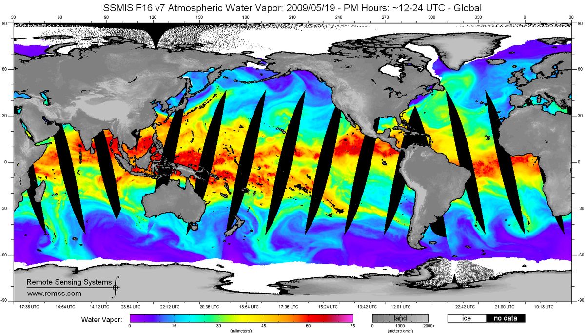
Researcher Maria Tsukernik and her colleagues discovered Antarctica's atmospheric rivers because of incredibly high snowfall recorded May 19, 2009, at a weather station in East Antarctica's Dronning Maud Land. On May 19, 2009, Belgium's brand-new Princess Elisabeth weather station recorded about 1.6 inches (40 millimeters) of snow from two big storms. Two more atmospheric rivers followed, in June and July, bringing the most snow to Dronning Maud Land since satellite tracking of yearly snow levels started in 1979. [In Photos: The Coldest Places on Earth]
Nearly 10 inches (250 millimeters) of snow fell in 2009, a record dumping not seen in the past 60 years, according to snow cores, which were detailed in a separate study published May 10 in the journal Geophysical Research Letters. After July 2009, the weather station saw almost no snowfall until October 2010.
"This sector has the least amount of moisture transported into the continental interior, and all of a sudden it had a very big anomaly in 2009," said Tsukernik, an atmospheric scientist at the National Center for Atmospheric Research in Boulder, Colo.
Tsukernik, who studies Antarctica's cyclones, wanted to see if the spectacular storms somehow caused the sudden uptick in snowfall. With an international team of colleagues, she scanned weather satellite data and discovered a huge water vapor plume heading straight for East Antarctica on May 19, from offshore of Madagascar. "This image looked a hell of a lot like this atmospheric river phenomenon," she said.
The anomaly was several thousand kilometers long but only a few hundred kilometers wide (like a river) and carried lots of water vapor. "This feature in the Southern Ocean very much qualified for all of the parameters of an atmospheric river," Tsukernik said.
Sign up for the Live Science daily newsletter now
Get the world’s most fascinating discoveries delivered straight to your inbox.
Tsukernik and her colleagues also found two more atmospheric river events, on June 16 and July 6 — both at the same time as Dronning Maud Land snowstorms. The findings reveal a significant link between East Antarctica and global climate, Tsukernik said. "This is linking Antarctica to the mid-latitudes, which is something new and a very important process in the moisture in East Antarctica," she said.
Tsukernik and colleague Irina Gorodetskaya of the University of Leuven in Belgium are now analyzing the unusual weather patterns that allow atmospheric rivers to reach into East Antarctica's ice desert. Normally, the strong cyclonic storms dancing clockwise around the continent sweep atmospheric moisture away from the coast, Tsukernik said. But in May 2009, a high-pressure ridge offshore of Dronning Maud Land provided a protective block, channeling the atmospheric river like a levee all the way onshore.
"The reason why this [atmospheric river] keeps bringing moisture to the coast of Dronning Maud Land was this high-pressure feature blocking the cyclone and preventing it from redistributing the water," Tsukernik said.
Email Becky Oskin or follow her @beckyoskin. Follow us @livescience, Facebook & Google+. Original article on LiveScience.

Most Popular

