'Fossilized Rivers' Reveal Clues About Disappearing Glaciers

An amazing landscape left behind by melting ice sheets offers clues to the future of Greenland's shrinking glaciers, a new study suggests.
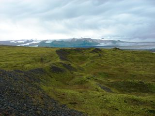
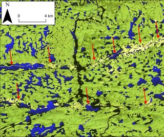
The incredible terrain is in northern Canada, which is ridged with thousands of eskers — the sinuous, gravelly remains of streams and rivers that flowed beneath the ice. Canada was once buried beneath miles of ice, similar to the way Greenland is today. Called the Laurentide Ice Sheet, this massive ice cap covered all of Canada and parts of the northern United States 15,000 years ago. When the Laurentide Ice Sheet started melting, the retreating ice left behind a record of its demise, such as the eskers, still visible on the Arctic tundra. Deciphering this record could provide a better forecast of the future of Greenland's changing ice sheet, scientists think.
"There's kind of a contentious debate at the moment about what's happening in Greenland," said lead study author Robert Storrar, a geomorphologist at Durham University in the United Kingdom. The debate hinges on what happens to the sapphire-blue meltwater that appears each summer on top of the Greenland ice. After the water finds a way to the bottom of the ice sheet, how does the water flow beneath the ice — in channels like rivers and streams, or in a different way, perhaps like a thin sheet, lubricating the ice? More important, as Earth's climate warms, will more meltwater make Greenland's glaciers speed up, ultimately increasing sea level rise? [Image Gallery: Greenland's Melting Glaciers]
"At the moment, the IPCC models don't take account of what the water looks like at all," Storrar said, referring to predictions by the Intergovernmental Panel on Climate Change.
A handful of studies have probed the problem directly, by drilling through the Greenland Ice Sheet or imaging its bottom. But Storrar decided to look at what Canada's eskers revealed about the underside of the Laurentide Ice Sheet.
"The idea was to reconstruct the deglaciation," Storrar said.
A year of eskers
Sign up for the Live Science daily newsletter now
Get the world’s most fascinating discoveries delivered straight to your inbox.
An esker is essentially a fossilized river or streambed, filled with sand, gravel and rocks, Storrar said. Water flowing beneath a glacier melts upward, into the ice, so over time, the sediment piles up into a ridge. (The ice walls provide support.) When the ice melts, it leaves behind an esker, tracing an inverted course across the landscape.
In Canada, Storrar measured eskers up to 470 miles (760 kilometers) long and 100 to 165 feet (30 to 50 meters) tall and wide. He counted 20,186 eskers in Keewatin (west of Hudson Bay) and Labrador (east of Hudson Bay), where two segments of the Laurentide Ice Sheet started shrinking about 13,000 years ago. An ice divide — a boundary between two opposite-flowing ice sheets — separated the segments.

The number of eskers in Keewatin dramatically increased as the Northern Hemisphere climate warmed and the ice sheet retreated, Storrar said. (The Northern Hemisphere climate started warming about 12,500 years ago, and the ice sheet disappeared about 7,000 years ago.) The Labrador section shows a similar pattern, lagging behind by a few thousand years. The Labrador section's retreat paused when it switched from floating on the Gulf of St. Lawrence to resting on land.
Past predicts the future
By matching the esker patterns to the timing of the ice-sheet retreat, Storrar and his colleagues think they've found evidence that meltwater under ice sheets organizes into channels when the ice shrinks in response to climate warming. The findings were published Jan. 10 in the journal Geology.
"As you're getting a warming climate, that drives surface melting of the ice sheet, that meltwater is getting into more and more drainage channels [beneath the ice]," Storrar said. "This evolution of the drainage suggests that meltwater organizes into drainage channels; it doesn't speed up the flow," Storrar told Live Science's Our Amazing Planet.
Meltwater rivers rush from underneath glaciers along the edge of Greenland's Ice Sheet, and the new study suggests that perhaps rivers and streams may also run under the mysterious middle of the giant ice sheet, either now or in the future.
"In terms of the future of the [Greenland] Ice Sheet, our results suggest the ice may not accelerate as drastically as it could have if meltwater is lubricating it," Storrar said.
Email Becky Oskin or follow her @beckyoskin. Follow us @OAPlanet, Facebook and Google+. Original article at Live Science's Our Amazing Planet.

Most Popular


