How El Niño Will Shift the World's Weather

The forecast for a drought-busting El Niño this winter has Californians as giddy as kids at Christmas.
An El Niño is the warm phase of a natural Pacific Ocean climate cycle driven by sea surface temperatures. The redistribution of hotter versus colder surface water triggers changes in atmospheric circulation that influences rainfall and storm patterns around the world.
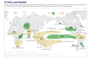
Warm water is piling up in the equatorial eastern Pacific Ocean right now, similar to the pattern that preceded the strong 1997-1998 El Niño, when California was drenched by a series of winter storms. The coming El Niño could finally bring real drought relief to California and other Southwestern states now in severe drought conditions. Based on past events, excess rainfall will also hit southeastern South America and eastern equatorial Africa, according to the National Oceanic and Atmospheric Administration (NOAA). [Infographic: Earth's Atmosphere Top to Bottom]
A new graphic from NOAA details El Niño's global impact on rainfall, from drought in Australia to flooding in India.
As the image shows, the change in global rainfall patterns caused by an especially powerful El Niño won't be welcomed everywhere in the world. The climate phenomenon will also bring drought to Indonesia, northern South America and southern Africa, NOAA said in a statement.
Email Becky Oskin or follow her @beckyoskin. Follow us @livescience, Facebook & Google+. Original article on Live Science.
Sign up for the Live Science daily newsletter now
Get the world’s most fascinating discoveries delivered straight to your inbox.

Most Popular

