Zap! New Map Charts Every Lightning Bolt

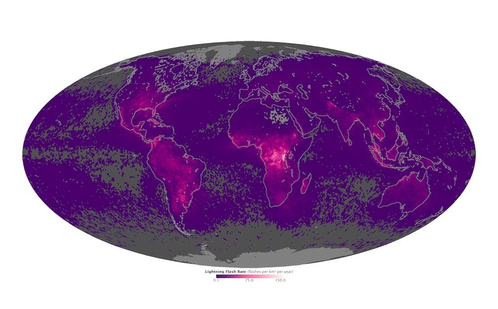
Every second, as many as 100 lightning bolts strike the Earth. Now, a new map reveals a tally of those flashes over the last two decades, tracing where they strike the planet each year.
Westward on the map, lightning flashes run down Mexico and Central America, before reaching their peak in Colombia and Venezuela; eastward, they peak in Singapore and Malaysia. But neither region compares to the dramatic strikes in the Democratic Republic of the Congo in Central Africa.
The data reveal that lightning is more likely to strike land than water, and these flashes occur more on land close to the equator. But the different intensities also reveal subtle differences in the storms themselves. [Electric Earth: Stunning Images of Lightning]
Lighting results from processes occurring within clouds. As ice particles within a cloud collide and break apart, the smaller particles acquire positive charge and the larger particles acquire negative charge. Updrafts of wind then push the small particles upward, until the top of the cloud is positively charged, while the bottom of the cloud is negatively charged. This separation of charge creates a huge electric potential within the cloud, and between the cloud and the ground.
Eventually, the electric potential grows strong enough to overcome the air's resistance to electrical flow. Negative charges venture toward the ground from the bottom of the cloud, causing positive charges to surge up toward the cloud from the ground. This electrical discharge is a surge of lightning. (At least that’s the simple version of lightning.)
Scientists are attempting to learn more about lightning and its accompanying thunderstorms by monitoring the flashes from above.
In 1998, NASA launched a Lightning Imaging Sensor on board its Tropical Rainfall Measuring Mission satellite. It was originally planned to be a three-year-mission, but the satellite is still up and running 17 years later. A second instrument, called the Optical Transient Detector (OTD) on the OrbView-1/Microlab satellite, also collected data from 1995 to 2000, and recorded all flashes above the 38th parallel north latitude.
Sign up for the Live Science daily newsletter now
Get the world’s most fascinating discoveries delivered straight to your inbox.
A lightning-imaging sensor collected near-infrared light to account for flashes occurring in daylight. "It's taking very rapid updates," said Daniel Cecil, a member of the Global Hydrology and Climate Center's lightning team. "So it will measure a background scene, and then with very rapid updates check to see if there's a sudden change in brightness from that background scene." If there is, the instrument records that as a flash of lightning.
Two basic trends can be seen across the data: Lightning is far more likely to occur on land than over the ocean, and lightning is far more likely to occur near the equator. Roughly 90 percent of the lightning strikes on Earth occur between the 38th parallel south and 38th parallel north latitudes, said Cecil.
But even on equatorial land, lightning strikes vary with different types of thunderstorms. Take Brazil, for example. With its abundant warm temperatures and moisture-laden air, this country commonly experiences large thunderstorms. The number of lightning strikes per storm, however, is relatively low, with only a few flashes per minute, Cecil said. But in places like northern Argentina, or even in the central United States, rare storms bring tens or hundreds of flashes per minute, he added.
"You get big differences for Brazil and central Africa, where they're both in the deep tropics, both overland," said Cecil, who is now working on further understanding this trend. "But in a lot of ways the storms over Brazil behave more like the storms over the ocean, which are almost always much weaker than the ones overland."
The researchers are planning to send a lightning imaging sensor to the International Space Station and to geostationary orbit (orbiting over the Earth's equator), where it will be able to continuously monitor certain spots on the planet, and therefore track certain storms.
"Right now, we're piecing together snapshots," Cecil said. "As a satellite goes over, we get to look at a storm for about a minute and a half. And in this next generation a few years from now, we're going to have continuous measurements. So as a storm pops up, we're going to see its entire life cycle from the first flash to the last."
Follow Shannon Hall on Twitter @ShannonWHall. Follow Live Science @livescience, Facebook & Google+. Original article on Live Science.


