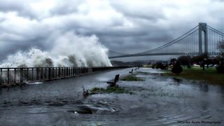
'Gray Swan' Hurricanes Could Strike Unexpected Places

"Gray swan" hurricanes — storms with impacts more extreme than history alone would predict — could ravage cities in Florida, Australia and the Persian Gulf, researchers say.
By the end of the century, climate change could dramatically increase the chance of damage from these unexpected storms, scientists added.
Rare, unpredictable events with major impacts have been called "black swans." In contrast, what Ning Lin, a climate scientist at Princeton University, and her colleagues dub "gray swans" are events with impacts beyond what might be thought of as likely based on the historical record alone. These "perfect storms" might be predicted using historical data together with climate models, they said. [A History of Destruction: 8 Great Hurricanes]
Whereas black swans' unpredictability makes them unavoidable, gray swans — at least in principle — could be foreseen and thus prepared for. To learn more about the dangers of gray swans, the researchers modeled the risks posed by the surges of water the storms could trigger. Storm surges are the most fatal and destructive aspects of storms — for instance, the storm surge from Hurricane Katrina a decade ago, which reached as high as 27.8 feet (8.47 meters), was partly responsible for the deaths of more than 1,800 people and the roughly $150 billion in damages, making that storm the costliest natural disaster in U.S. history.
The scientists focused on Tampa, Florida; Cairns, Australia; and the Persian Gulf. They chose these three regions because scientists conducting prior studies may not have recognized how vulnerable those regions are to extreme storms, "as they have never had intense tropical cyclones in their history, or haven't experienced one for a long time," Lin told Live Science. (The most powerful tropical cyclones may be known as hurricanes or typhoons, depending on where they occur.)
Although the Persian Gulf has no known history of tropical cyclones, the researchers found it faced a potentially large risk of these extreme storms. By simulating 3,100 tropical cyclone storm surges (using computer models) based on climate data from 1980 to 2010, the scientists found that Dubai had a chance of storm surges reaching as high as about 13 feet (4 meters) about once every 10,000 years. In comparison, the storm surge from Hurricane Sandy reached 9.41 feet (2.87 m) at Battery Park in New York. [On the Ground: Hurricane Sandy in Images]
"These findings indicate that we can get things that are far beyond the very limited historical records — that is, gray swans," Lin said.
Sign up for the Live Science daily newsletter now
Get the world’s most fascinating discoveries delivered straight to your inbox.
The researchers explained that the Persian Gulf contains hot, shallow, very salty water that can support the development of intense tropical cyclones and storm surges. For instance, Cyclone Gonu in 2007 — the strongest known tropical cyclone in the Arabian Sea, which inflicted $4.4 billion in damage — came close to entering the Persian Gulf, making landfall at the mouth of the Gulf on the easternmost tip of Oman. The majority of simulated cyclones originated within the Gulf, rather than in the Arabian Sea, and these caused the most extreme surges there that the researchers modeled.
The scientists also found that Tampa faced a larger-than-expected hurricane threat. By simulating 7,800 hurricane storm surges based on climate data from 1980 to 2005, they discovered gray swan events striking the city could lead to storm surges reaching as high as about 20 feet (6 m). Tampa is highly susceptible to storm surges — although fewer storms have made landfall in this area than in regions farther north and west on the Gulf Coast or farther south on the Florida coast, Tampa Bay is surrounded by shallow water and low-lying lands, and a 20-foot rise of water can inundate much of Tampa Bay's surroundings.
In addition, Cairns faced a larger-than-expected threat from tropical cyclones. By simulating 2,400 tropical cyclone storm surges based on climate data from 1980 to 2010, the investigators found that gray-swan events striking Cairns could lead to storm surges reaching as high as about 19 feet (5.7 m).
The risk of these extreme surges will likely grow in the coming century, as climate change is expected to increase both the number and intensity of storms, the researchers said. For instance, although the scientists found a 20-foot surge currently had about a one in 10,000 chance of hitting Tampa each year, by the end of the century, the likelihood of such a surge in any given year would be about four to 14 times higher than it is today, the researchers found.
"Storm-surge risk is likely to increase in the coming century," Lin said. "Planners and decision makers may think more about extremes beyond the historical records and experiences."
The scientists detailed their findings online today (Aug. 31) in the journal Nature Climate Change.
Follow Live Science @livescience, Facebook & Google+. Original article on Live Science.
