Premature Tropical Storm Not Due to Global Warming, Scientists Say
Updated at 02:40 p.m EDT
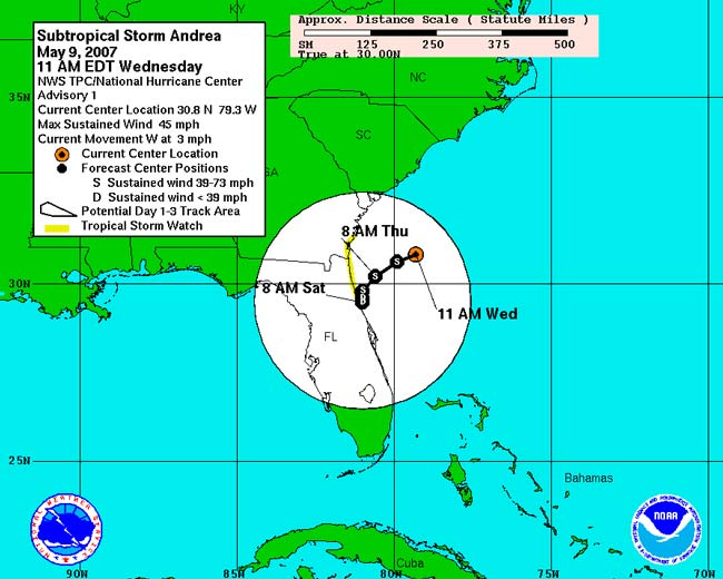
The first named Atlantic storm of 2007 crept in today well before the season's official June 1 start, raising the question of whether global warming is responsible for the early arrival. Flowers, tree leaves, birds and other signs of spring have appeared earlier in recent years at various spots globally, so can Subtropical Storm Andrea's arrival three weeks ahead of schedule also be blamed on climate change? "Oh, gosh, no," said James Kossin, meteorologist at the University of Wisconsin-Madison. It’s not all that unusual for a storm to form early, and there is no real significance to Andrea's arrival in the second week of May, he said.
"There's enough standard deviation on either side of [the hurricane season dates] to not make a whole lot of difference," Kossin told LiveScience. Numerous studies have predicted that global warming may produce more intense hurricanes, and might even increase their raw numbers as well, although not everyone agrees on either point. Kossin says the impact of global warming on hurricanes will manifest in a "trifecta of ways: frequency, duration and strength." In fact, it probably already has started, he said, though such a trend is hard to see in the short term. "There's a lot of this inter-seasonal variability, and there's a fairly large distribution about the [average]," he said. "None of that is necessarily a sign of global warming. But if you go back in the record and look at the long term, you can kind of smooth out that inter-annual variability and see if there's a trend." History of pre-June named storms Subtropical Storm Andrea is hardly the first pre-June 1 named storm of any hurricane season on record, said Greg Romano, a spokesman for the National Weather Service. “[Early storms] are not rare, but they’re not common," he said. "It’s fair to say they’re uncommon.” As recently as 2003, Tropical Storm Ana formed on April 20. Eighteen tropical storms and four hurricanes have formed in May since 1851, and six storms have formed before the June 1 start since 1951. The earliest observed hurricane in the Atlantic formed on March 7 in 1908. Officially, Andrea is classified as a subtropical storm—it has the characteristic circulation of a typical tropical storm, but, like winter storms such as Nor’easters, it is missing the convection usually observed in the center. “It’s really a hybrid of the two,” Romano said. The June 1 and November 30 start and end dates to the hurricane season were picked because they mark the period when conditions are generally right for storm formation, for example, when waters in the Atlantic become warmer. But storms can form when these conditions occur earlier. Like the hyperactive hurricane season in 2005, which saw both early and late formations of storms, the 2007 season could also be an active season, according to predictions. James Elsner, director of the Hurricane Center at Florida State University, said those forecasts are credible. "The oceans continue to be warmed, and unlike last year, we don't have an El Niño event in the Pacific," he said. The wind shear from such events tends to depress hurricane formation. "So we shouldn't see as much wind shear over the Atlantic as we saw lat year," he said.
- 2007 Hurricane Guide
- Atlantic's 1st Named Storm Forms Early
- All About Hurricanes
Sign up for the Live Science daily newsletter now
Get the world’s most fascinating discoveries delivered straight to your inbox.

Andrea Thompson is an associate editor at Scientific American, where she covers sustainability, energy and the environment. Prior to that, she was a senior writer covering climate science at Climate Central and a reporter and editor at Live Science, where she primarily covered Earth science and the environment. She holds a graduate degree in science health and environmental reporting from New York University, as well as a bachelor of science and and masters of science in atmospheric chemistry from the Georgia Institute of Technology.
