Tornado Country
Big Spinner

Tornadoes are low pressure systems, and can generate wind velocities that can exceed 200 mph. Severe ones will flatten buildings (tornadoes have a special fondness for trailer parks), uproot trees, and carry objects for hundreds of feet to even miles from their spot of origin. On May 27, 1997 several lines of storm clouds bearing multiple funnel clouds crossed central Texas with deadly results. Here is a GOES-8 image of these advancing fronts.
Approaching Dallas

Tornado clouds swirl as fast as hundreds of kilometers per hour and, when they touch down, can destroy nearly everything in their long, narrow path. Many tornadoes last only a few minutes, but the largest and most dangerous can endure for hours. The above image, although somewhat unfocussed, appears to show a dropping funnel cloud interacting with a light pole. If so, and this interpretation is controversial, this photograph would be one of the few indicating a clear distance to the funnel cloud. The pictured tornado occurred in 1981 in Dallas, Texas, USA.
Deadly Twister
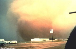
This tornado's swirling motion picks up steam near a local petroleum stop.
Storm Chasers
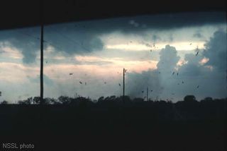
El Reno OK, 30 April 1978, looking W. This photo was shot from the back of a storm intercept vehicle while fleeing a tornado, which developed almost directly overhead. In other words, the chasers became the chased. The tornado touched down on a small house a few hundred feet away, pulling its roof off and scattering all manner of boards, shingles and other debris through the air.
Historical Perspective
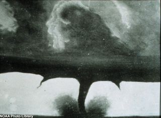
Shown above is the oldest known photograph of a tornado taken near Howard, South Dakota, on August 28, 1884.
Sign up for the Live Science daily newsletter now
Get the world’s most fascinating discoveries delivered straight to your inbox.
