'Beaver Tail' Tornado Hits Oklahoma

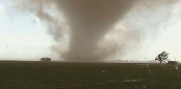
At least one tornado — and most likely many more — ripped through southwest Oklahoma last night (Nov. 7) due to textbook twister weather, just days after the biggest earthquake in the state's history.
One twister has been confirmed by the National Weather Service (NWS) in Norman, Okla., and today, their storm damage survey teams will deploy to investigate the tornado tracks. They will most likely confirm other tornadoes and rate their strength.
"There were probably quite a few more than one tornado," said Mark Austin, a meteorologist at the NWS office in Norman.
Baseball-size hail pounded the state. Wind gusts up to 92 mph were reported. A twister flipped a storm-chaser's car, but he escaped unscathed.
Many buildings in Oklahoma are vulnerable to severe weather after a magnitude 5.6 earthquake rocked the state this past weekend. The earthquake was the largest in the state's history, and was bookended by a magnitude 4.7 foreshock and a magnitude 4.7 aftershock, which struck last night.
No twister-related injuries have been reported, but an Oklahoma State University extension office was destroyed in Tillman County, in the southwest part of the state.
Storm survey teams will be analyzing the damage today to determine the storms' strength on the Enhanced Fujita tornado damage scale. The last EF-2 or stronger tornado to hit Oklahoma in November was in 1987, according to the Weather Channel.
Sign up for the Live Science daily newsletter now
Get the world’s most fascinating discoveries delivered straight to your inbox.
"We have survey crews going out today and they're going to verify that all those tornadoes were confirmed before we send out our reports," Austin told OurAmazingPlanet.
Tornado Alley's picturesque tornadoes are formed by the collision of warm, moist air from the Gulf of Mexico and cool, dry Arctic air. Yesterday, Oklahoma had quite a bit of moisture in the air, combined with lots of instability due to temperatures in the mid-70s Fahrenheit (around 21 Celsius), and a good bit of wind shear, the change in wind direction over a short height.
"It was pretty much typical of what you would see with any tornado outbreak," Austin said.
To form a tornado, the warm air rises and hits the wind shear and creates the rotation — think of a pinwheel with air pushing in opposite directions on the top and bottom. Below the pinwheel, a cap of warm air bottles up surface heat below about 10,000 feet (3,000 meters).
Heat builds until it punches through the cap, triggering a thunderstorm. With enough air shooting up and down, the pinwheel is knocked on its side, creating a huge rotating mass of clouds called a mesocyclone — the hallmark of a tornado-spawning supercell storm — from which a funnel cloud can shoot down.
Several apparently distinct twisters were captured on videos posted to YouTube. One twister had a "beavertail" and another twister had a classic "stovepipe" funnel, said the Weather Channel's Greg Forbes.
A beavertail shoots out of the bottom of a funnel cloud where the storm is sucking in air that is warm and moist — in other words, unstable — Austin said. Moisture yesterday even poured over the mountains in southwest Oklahoma, then condensed and formed tails in wall clouds, the low, rotating clouds that can spawn tornadoes.
The outbreak marked the first big action of the second-tornado season, which usually hits hard in Dixie Alley in the late fall, southeast of the well-known Tornado Alley.
More severe weather has been forecast for the Plains today, from Springfield, Mo., to southwest Louisiana.
You can follow OurAmazingPlanet staff writer Brett Israel on Twitter: @btisrael. Follow OurAmazingPlanet for the latest in Earth science and exploration news on Twitter @OAPlanet and on Facebook.


