June-uary Weather: 6 More Weeks of Mild Winter?
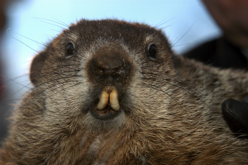
Punxsutawney Phil, the weather-forecasting groundhog, saw his shadow today (Feb. 2), which is supposed to mean six more weeks of winter are to come. Just about everyone in the United States, except for Alaska, can be forgiven for thinking, "What happened to the first six weeks of winter?"
This past January was an oddball. After two years of winter storms with unofficial names including "snowpocalypse" and "snowmageddon," this winter hasn't yet had any snowstorms worthy of clever names. "Snow-tober," when a rare snowstorm hit the East Coast on Halloween, was the best we've had so far, but that was in the fall. As OurAmazingPlanet previously reported, and everyone has realized this year, October snowstorms are not a guaranteed sign of a wild winter ahead.
Official statistics on how warm January 2012 was will be released Tuesday by the National Climatic Data Center. But even without the official data, it's clear that the nation has seen struggling ski slopes and ice fishers with no ice to fish on. In the Twin Cities, the temperature did not drop below 0 degrees Fahrenheit (minus 17.7 degrees Celsius) until Jan. 18. That tied for the latest date for the weather station's first 0 degree F day of winter.
But not everywhere in the nation has been unusually warm. The atmospheric conditions behind this unseasonable winter have mostly focused on the East Coast and Midwest. [Weirdo Weather: 7 Rare Weather Events]
Climate culprits
Temperatures this time of year in the East Coast are partially driven by a climate pattern of opposing atmospheric pressures in the middle and high latitudes of the Northern Hemisphere, called the Arctic Oscillation, Jake Crouch, a climatologist at the National Climatic Data Center in Asheville, N.C., told OurAmazingPlanet.
The past two winters, the Arctic Oscillation, or AO, was mostly in a record-strength negative phase. This year, the AO has been in a positive phase. When the AO is positive, the Eastern Seaboard, Midwest and Southeast tend to have warmer-than-average temperatures.
Sign up for the Live Science daily newsletter now
Get the world’s most fascinating discoveries delivered straight to your inbox.
In the Great Lakes so far this year, not much cold air has been blowing over the big bodies of water, so the region has seen little of its infamous lake-effect snow.
Lake-effect snow is created when bitter Arctic air spills south over the relatively warmer Great Lakes. The cold air warms, moistens and forms into snow clouds, which drop the white stuff in whichever direction the strongest wind is blowing. Lake-effect snow is heaviest downwind, or leeward, of a water body.
Snowy surprises
Even though much of the nation is missing snow, the 2011 winter has given a few fleeting surprises.
The early snowstorm that smacked the East Coast on Halloween weekend knocked out power to thousands in Connecticut. New York's Central Park recorded 2.9 inches of snow (7.6 centimeters), the first time since record-keeping began in 1869 that an inch or more of snow has been recorded there during the month of October, according to the National Weather Service (NWS).
A week before, that same weather system created wild weather in Denver. The Colorado capital saw temperatures of 80 degrees F (27 degrees C) on Oct. 24, a record for the day in Denver. Snow and freezing temperatures came in with the winter system the next day.
It wasn't much, but on Nov. 28, Alabama saw a November snowfall for the first time in 35 years. The southern snow was caused by a "cold bubble" that settled over the region.
Seattle, called the Emerald City, was all white during a rare January snowstorm. A "perfect recipe" for snow hit the Pacific Northwest on Jan. 18, said Dave Samuhel, a meteorologist with AccuWeather.com. The storm brought nearly a winter's worth of snow to Seattle in a matter of hours.
Perhaps the biggest surprise this winter has been Midland, Texas. The west Texas town saw its biggest snowfall ever on Jan. 9 with 10.5 inches (26.7 cm).
Where is winter? In Alaska.
In Fort Yukon, Alaska, 145 miles (233 kilometers) northeast of Fairbanks, the average high temperature this January has been minus 17.7 F (minus 27.6 C), according to the U.S. National Oceanic and Atmospheric Administration. The average low has been minus 35 F (minus 37.2 C). To put that in perspective, car tires will shape-shift from round to square at minus 45 F (minus 42.7 C).
Several atmospheric forces have come together to create Alaska's cold winter, said meteorologist Christopher Cox with the NWS office in Fairbanks.
A climate pattern known as the Pacific Decadal Oscillation is under way, which tends to keep Alaska cooler than normal. La Niña, a cooling of the waters of the equatorial Pacific, has also been in play, and it typically creates colder temperatures for Alaska.
In the last few days to weeks, a mega-blocking pattern has also contributed by trapping Arctic air over Alaska.
This week, the snowy weather could spread beyond Alaska. A blizzard watch is under way for the Central Plains through Feb. 4.
You can follow OurAmazingPlanet staff writer Brett Israel on Twitter: @btisrael. Follow OurAmazingPlanet for the latest in Earth science and exploration news on Twitter @OAPlanet and on Facebook.
