So Long Winter: How Did 2012's Snow Stack Up?
With temperatures more like summer this week, winter is but a distant memory for most of the United States. Looking back at this winter's snow totals, it seems winter was barely even here.
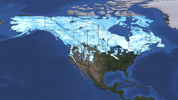
The mild winter of 2012 did not have any major snow storms, which made it feel like a dud after the "snowpocalypse" of 2011. Two snow cover maps made by NASA show exactly how different the winters of 2011 and 2012 were.
The snow cover maps show the difference between snow extents on March 3, 2011, and March 5, 2012. The maps were made using data from the Moderate Resolution Imaging Spectroadiometer (MODIS) instrument aboard NASA's Terra satellite.
In 2012, areas that are usually snow covered are bare, including parts of Montana, Wyoming and South Dakota. The Snake River Plain in southern Idaho is clearly visible. This low-lying valley is the track of the hotspot that lies under Yellowstone National Park. In the east, the Great Lakes area, southern Ontario and the East Coast of the United States have much less snow cover than they did at this time last year.In 2012, the snow cover is very spotty compared to 2011. In 2011, the Great Lakes were clearly defined by surrounding snow, and snow blanketed the Rocky Mountains, Nevada's Basin and Range and the Sierra Nevada all the way into southern California.
2012's relatively light snowfall is the result of two atmospheric processes, according to climatologist Bill Patzert of NASA's Jet Propulsion Laboratory in Pasadena, Calif. One is the La Niña conditions in the Pacific, which result in less moist air crossing the continental United States. The other is a strong Arctic Oscillation that keeps cold arctic air around the North Pole and away from more southerly latitudes.
Follow OurAmazingPlanet for the latest in Earth science and exploration news on Twitter @OAPlanet and on Facebook.
Sign up for the Live Science daily newsletter now
Get the world’s most fascinating discoveries delivered straight to your inbox.

