Satellite Sees 'Strongest Tornadoes in Years' Strike Texas
Editor's note: This story has been updated to include new information from the National Weather Service on the number and strength of the tornadoes.
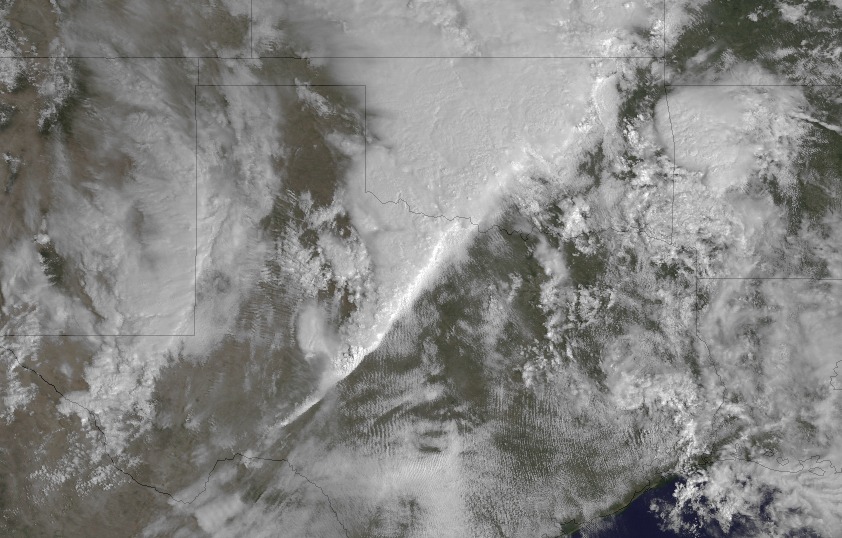
A NOAA satellite spotted the line of powerful storms that ripped across south-central Texas last night (March 19), producing three tornadoes that left a path of destruction in their wake.
While officials were trying to assess the damage today, NASA produced a video based on images from the National Oceanic and Atmospheric Administration satellite.
Storm survey teams arrived at the site of splintered homes early this morning in Medina County, an area near San Antonio, in the aftermath of some of the most severe weather the south-central Texas region has seen in years, said Jon Zeitler, science and operations officer at the National Weather Service's Austin/San Antonio forecast office.
Already 2012 has been a busy tornado year. In early March, a month's worth of tornadoes struck the Midwest in a single day, killing dozens of people.
At least two dozen people were injured in the powerful Texas storms, two of them possibly seriously, yet no fatalities have been reported.
Late this afternoon (March 20), the forensic team confirmed the storm had produced three tornadoes. "They had quite a bit to survey," Zeitler said.
Sign up for the Live Science daily newsletter now
Get the world’s most fascinating discoveries delivered straight to your inbox.
The first and largest twister struck near Devine, Texas, and plowed a path 3.5 miles long (5.6 kilometers). The quarter-mile-wide tornado was an EF-2, with winds 115 mph (185 kph), Zeitler said.
A second, smaller tornado, an EF-1 with winds 110 mph (177 klph), was 150 feet wide (45 meters), and hit near the town of Natalia.; it stayed on the ground for 7 miles (11 km).
A third tornado, an EF-2, hit near an unincorporated area.
In total, the tornadoes damaged 25 to 30 homes; about half were mobile homes and were largely destroyed, Zeitler said. [The Tornado Damage Scale In Images]
"These are the strongest tornadoes we've had in almost five years," Zeitler told OurAmazingPlanet.
Officials rely on storm spotters to confirm the presence of a tornado, and since the storms struck at night, the twisters were difficult to see.
Forecasters had been keeping an eye on a developing storm system beginning eight days earlier, Zeitler said, and the NWS offices were fully staffed when the first tornado watch was issued at 2:40 p.m. local time Monday (March 19).
The first of three tornado warnings was issued at 6:07 p.m. that evening; in total, warnings in the area were in effect for nearly four hours.
The NASA video reveals a furious swirl of thick clouds converging over the affected regions beginning Sunday night (March 18), at around 10 o'clock local time. In the video, the powerful storm front comes together in the shape of a wedge of clouds pointing south.
"The storms were moving around 15 to 25 mph, which isn't particularly fast," Zeitler said, "but that's why the warnings continued for such a long period and those storms maintained their severity for such a long time."
Texas has been in the grip of a severe drought over the last several years, and such severe storms had become a rarity in the 33 counties Zeitler's office monitors. However, it appears that this year, as La Niña's drought-inducing conditions fade away, more typical weather patterns — and more severe weather — may return to the area, he said.
Reach Andrea Mustain at amustain@techmedianetwork.com. Follow her on Twitter @AndreaMustain.Follow OurAmazingPlanet for the latest in Earth science and exploration news on Twitter @OAPlanetand on Facebook.
