Arctic Sea-Ice Melt Picks Up, Could Set Record
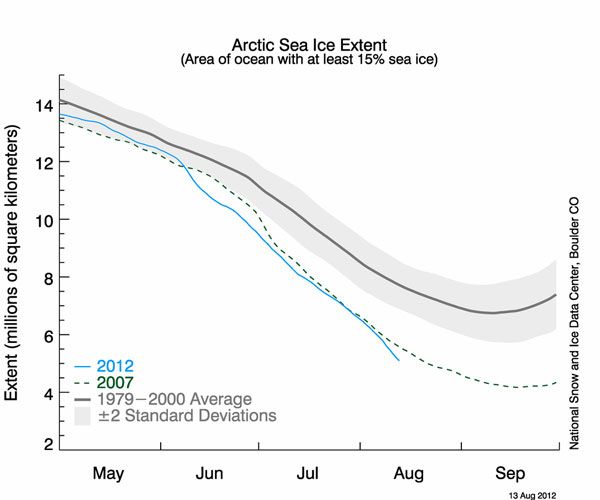
In roughly a month, Arctic sea ice is expected to reach its annual minimum extent, but already, this summer's trend has the look of unusually low-ice year.
As of Monday (Aug. 13), satellite data indicated that the sea-ice extent — the area of water with at least 15 percent sea ice — had dipped below the previous record low for that date, in 2007. Specifically, the sea-ice extent had receded to 1.9 million square miles (4.9 million square kilometers), according to the U.S. National Snow and Ice Data Center (NSIDC).
"It is not looking good right now, if you like sea ice," said Mark Serreze, director of NSIDC at the University of Colorado, Boulder.
Sea ice matters to the animals — polar bears and walruses — that inhabit it. Changes in sea-ice cover also have far-reaching effects on climate. White ice reflects more energy back out into space than does the dark, ice-free water, which absorbs heat. More dark water exposed by receding ice results in more energy being taken up, which in turn melts more ice.
Every year, sea ice builds up over the Arctic waters during the winter then melts through the summer, reaching an annual minimum in early to mid-September. Continuous satellite records of sea-ice extent go back to 1979. In recent years, a trend toward declining sea-ice cover, with record-setting lows, has emerged.
The previous record minimum occurred on Sept. 16, 2007, when the ice extent reached 1.59 million square miles (4.13 million square kilometers), according to NSIDC data. A German group based at the University of Bremen used different measurements to conclude that September 2011 saw the record low.
Researchers attribute this to a combination of global warming and natural fluctuations in weather.
Sign up for the Live Science daily newsletter now
Get the world’s most fascinating discoveries delivered straight to your inbox.
For instance, the melt rate this summer nearly doubled in early August during a strong Arctic storm.
"This could be due to mechanical break-up of the ice and increased melting by strong winds and wave action during the storm. However, it may be simply a coincidence of timing, given that the low concentration ice in the region was already poised to rapidly melt out," reads a statement on the NSIDC website.
Follow Wynne Parry on Twitter @Wynne_Parry or LiveScience @livescience. We're also on Facebook & Google+.


