NASA Photo Shows Severe Siberian Fire Season

It's been a bad year for wildfires in Russia: The country has seen its worst fire season in a decade.
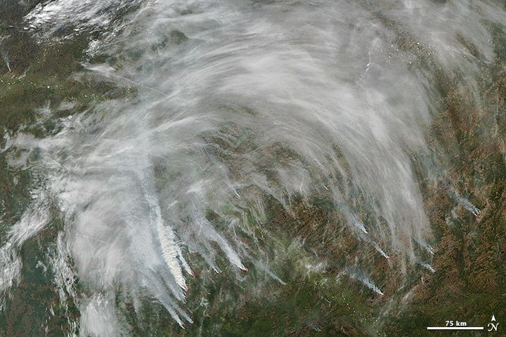
Many of the fires are centered in Siberia, and have burned through the taiga, or coniferous forests.
In this photo, taken on Sept. 11 by NASA's Aqua satellite, thick smoke billows from numerous wildfires near the Ob River in south-central Siberia. Red outlines indicate spots where the satellite detected hot surface temperatures associated with fires.
This year there have been more than 17,000 large Russian wildfires, which have burned more than 115,625 square miles (299,467 square kilometers), according to researchers at the Sukachev Institute of Forest in the Russian Academy of Sciences. That's an area roughly the size of Arizona or the Philippines.
Compare that to last year when only 77,220 square miles (200,000 square km) burned, which is about average for the last decade, according to a NASA release.
Christine Wiedinmyer, a scientist at the National Center for Atmospheric Research in Boulder, Colo., used satellite measurements to determine thatRussian wildfires produced more carbon monoxide this year than any year since 2003. Wildfires produce about half of all carbon monoxide in the atmosphere, according to NASA.
It's been a bad year for wildfires in the United States as well, partially due to the intense drought gripping much of the country.
Sign up for the Live Science daily newsletter now
Get the world’s most fascinating discoveries delivered straight to your inbox.
Reach Douglas Main at dmain@techmedianetwork.com. Follow him on Twitter @Douglas_Main. Follow OurAmazingPlanet on Twitter @OAPlanet. We're also on Facebook and Google+.


