Urban Land Set to Triple By 2030, Study Suggests

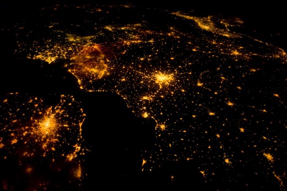
Urban development is set to triple in the first three decades of this century, the largest cityscape expansion in human history, according to a new study that for the first time maps out urbanization hotspots.
The rapid urban growth will come at a cost. Researchers predict the sprawl will swallow up a landmass nearly equivalent in size to South Africa (463,000 square miles, or 1.2 million square kilometers), consume delicate habitats, eliminate an estimated 200 endangered species and will mow down carbon-storing vegetation.
"Over the next 18 years, the world will witness an unprecedented boom in urban expansion," said lead study author Karen Seto, associate professor in the urban environment at Yale University.
That boom will impact people worldwide as demand for raw materials and energy resources increases to build infrastructure, including roads and buildings for urban residents, the researchers said.
"This is not an issue limited to one place or one country, but this is a large-scale global trend; we are now in the century of the city," Seto said of the expansion that will be the equivalent of 20,000 American football fields each day for 30 years. [Top 10 Ways to Destroy Earth]
The majority of predicted urban growth (55 percent) is expected to occur in Asia, including a 1,800 km (1,100 miles) east coast urban corridor in China that stretches from Hangzhou to Shenyang plus seven state capitals throughout India.
"Urbanization has been neglected as a factor in deforestation and degradation and their contribution to carbon emissions. The projections are pretty sobering," said Hilda Blanco, interim director of the Center for Sustainable Cities at the University of Southern California, who was not involved in the study. "The study elevates the issue from a more regional to a worldwide scale."
Sign up for the Live Science daily newsletter now
Get the world’s most fascinating discoveries delivered straight to your inbox.
Modeling city growth
Though the United Nations began tracking the global shift to urban centers in 1969, their data used broad strokes that was determined by looking at countrywide shifts.
In the new study, researchers from Yale, Texas A&M and Boston Universities mapped urban growth predictions at a local scale by slicing up the world into a grid where every square represented 25 square kilometers (9.65 square miles).
The trio modeled urban growth in each grid by combining five different datasets: urban growth predictions from the United Nations currently available at the country level; anticipated GDP growth, an indicator of urbanization; NASA satellite mapping data of existing urban areas, overall population projections and population density estimates.
Some results, Seto said, were unexpected. For instance, the models suggested Mexico would undergo intense urban growth in a few specific regions, even as the country overall has a low expectation of urban growth. Meanwhile, the modelers found Turkey, also expected to have low urban growth, would not experience these same intense points of city expansions.
The researchers also overlaid the urban predictive map with 34 known biodiversity hotspots, places threatened the most by human development. Only 1 percent of urban development currently exists in these hotspots, but by 2030, that number would nearly double to 1.8 percent, leading to the extinction of 139 amphibian, 41 mammalian and 25 critically endangered bird species. [Biodiversity Abounds: Stunning Photos of the Amazon]
The urban spread will also consume vegetation that stores carbon, which when released, would act as a heat-trapping "greenhouse" gas.
Limits of urban growth
Not all countries will be directly affected; the modelers predict that 48 out of 221 countries will see little to no urban growth.
And what that urbanization will look like will vary by countries. In this study, the researchers defined urban land as impervious whether from buildings or roads or surrounding infrastructure such as sidewalks. Agricultural land or forest was not included as urban.
However, "what is 'urban' for an Icelander may be a 'small rural village' in one of the eastern provinces of China," Gerhard K. Heilig, chief of the Population Estimates and Projections Section at the United Nations,wrote. "The diversity of these definitions is even greater on a city level. "Countries may have several definitions of a particular urban area — such as 'city proper,' 'urban agglomeration,' 'metropolitan area,' etc. Depending on what definition is used, city populations may be very different."
The study also has its had limitations, Heilig pointed out, including out-of-date data used to estimate world prospects for urbanization and the uncertainty of future population projections; an underestimation of uncertainties behind the estimates; and a time dynamic based on a single year, though data across several time points is available.
The study also didn't factor in that depopulation of rural regions could compensate for natural habitat loss due to urban expansion. "In fact, forested areas are expanding in some parts of the world, as a consequence of rural-urban migration," Heilig wrote. The study also didn't include data about roads, an indicator of urban growth since more road access means a higher likelihood of development.
The researchers plan to use the model as a starting point to look at energy and material demands along with modeling local climate and precipitation.
"The cities of tomorrow have not yet been built, there is a lot we can do to shape what these places will become," Seto said.
The study is detailed online today (Sept. 17) in the online edition of the Proceedings of the National Academy of Science.
Editor's Note: This article has been updated to correct a misspelling in one instance of Heilig's name.
Follow LiveScience on Twitter @livescience. We're also on Facebook & Google+.


