Typhoon Curve and Northern US Cold Connection
This article was provided by AccuWeather.com.
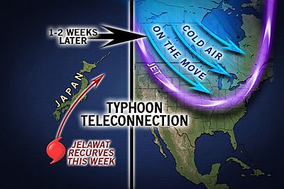
Based on the future movement of Typhoon Jelawat and Tropical Storm Ewinar, cold air may plunge into part of the northern U.S. days later.
You could call it the typhoon teleconnection, or the Tokyo, Chicago-New York connection, or something of that sort.
AccuWeather.com meteorologists have observed for years that whether tropical cyclones in the Western Pacific curve away from Asia or plow inland over China determines whether or not cold air aims for portions of the Midwest and Northeast approximately 10 to 14 days later.
According to Expert Senior Meteorologist Bob Smerbeck, "When a typhoon or strong tropical storm curves to the northeast along the coast of Asia, the way the jet stream gets jumbled up in the process usually allows a batch of chilly air to plunge southward from Canada to the swath from the northern Rockies to the northeastern U.S."

The jet stream is a zone of high speed winds at high levels of the atmosphere that often marks the path weather systems will take. The jet stream typically marks the boundary between cool air to its north and warm air to its south.
In short, the way a tropical cyclone curves northeast of Japan amplifies the jet stream over the Pacific Ocean and North America.
Sign up for the Live Science daily newsletter now
Get the world’s most fascinating discoveries delivered straight to your inbox.
Exactly how strongly the tropical system curves will determine the wavelength and position of jet stream ridges and troughs over the Pacific Ocean and North America. (A ridge is a northward bulge of warm in the jet stream; a trough is a southward dip of chilly air.)
"In the case of Typhoon Sanba, which curved away from southeastern China around Sept. 14, 2012, but slammed Korea before heading north of Japan around Sept. 16, we had big ridge set up in the western and eastern Pacific with a trough in the middle of the Pacific and a trough over the Upper Midwest and Northeast U.S. during the latter part of September," Smerbeck said.
The situation in the Western Pacific now is a bit more complex in that we have two tropical cyclones, so we may not have a textbook case of how the push of cold air behaves a couple of weeks later.
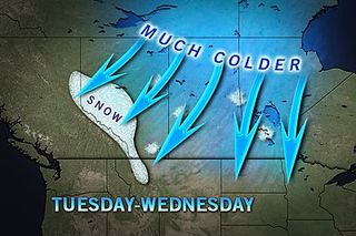
We do believe that as Jelawat curves northeastward across Japan and Ewinar curves east of Japan this weekend, a push of cold air will begin to drive southward next week over western Canada," Smerbeck said, "From there, the cold push may get hung up over the North Central states or could drive more into the Great Lakes and Northeast next weekend into week two of October."
When tropical cyclones plow northwestward into mainland China and diminish, there is no direct connection in the weather a couple of weeks later for the northern U.S. Neither Jelawat nor Ewinar are forecast to reach westward into mainland China.
© AccuWeather.com. All rights reserved. More from AccuWeather.com.
With much of the country experiencing an unseasonably warm winter, fears of climate change come to mind. See how well you understand recent weather, climate and the difference between them.
Weather vs. Climate Change: Test Yourself
