Removing the Terror of Flying Into Alaska's Capital

(ISNS) -- People flying into Juneau, Alaska's state's capital, are familiar with the meaning of the word "terror."
The city's airport, located off a channel of cold water and surrounded by steep snow-capped mountains and glaciers, is notorious for the kind of wind-driven turbulence that can turn even experienced fliers pale. Only one major airline regularly flies there.
Researchers at the National Center for Atmospheric Research, the Federal Aviation Administration, and Alaska Airlines are now using an electronic monitoring system that takes some of the fear out of flying to Juneau. The system monitors wind shear -- a quick change in wind speed and direction -- and turbulence data in the area so air traffic controllers can inform pilots of areas to avoid.
Since Juneau is the only state capital inaccessible by road -- you either fly in, or take the Alaska Marine Highway ferry 15 miles up the Gastineau Channel -- this new system is no small matter for residents of America’s largest state.
The Juneau Airport Wind System, or JAWS, can be used at any airport where wind can produce severe turbulence. The FAA is planning to expand its use in other airports with similar problems.
"Since its inception, not one aircraft has experienced a severe upset or severe turbulence encounter within the coverage of the JAWS system," said Kenny Williams, an Alaska Airlines 737 supervisor pilot.
JAWS is based on a technology originally developed for use in Hong Kong, an island city surrounded by mountains that also produce wind shear, said Cory Morse, a software engineer at NCAR who worked on the Alaska system.
Sign up for the Live Science daily newsletter now
Get the world’s most fascinating discoveries delivered straight to your inbox.
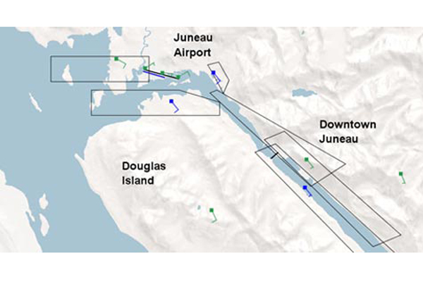
Juneau International Airport has only one runway, sitting at the end of the Gastineau Channel and aimed southeast-northwest. Landing or taking off there is particularly hazardous even when the wind isn't blowing. In 1971, an Alaska Airlines Boeing 727 flew into a mountain on approach to Juneau, killing 111 people, at the time, the worst single-plane accident in U.S. history. The National Transportation Safety Board blamed confusing instrumentation and pilot error.
JAWS was triggered, however, by an extraordinary near-disaster 22 years later.
In winter, the wind at Juneau usually comes from the southeast, over the steep mountains and booming up the channel. Most takeoffs are in that direction, and until a few years ago, planes had to make an immediate, exciting 180-degree right turn to avoid hitting a mountain as soon as they leave the ground.
On Jan. 30, 1993, an Alaska Airlines 727 took off into the wind and began its turn when it was hit by a blast of wind combined with a wind wave off the mountains. The plane was banking to the right 30 degrees at the time. The gust knocked the 727 on its side, its wings vertical, and hurled the large jet toward the ground. The crew regained control with only 150 feet to spare.
Remarkably, no one was hurt.
The FAA clamped down, closing the airport for landings and takeoffs when the winds blew too strongly for safety. Delta Airlines, one of two serving Juneau, pulled out in 2006, partly for safety reasons and partly because the delays and cancellations made flying to Juneau uneconomic.
Alaska Airlines remained and began work on a system to make flights safer and more reliable.
NCAR began working on the project under contract to the FAA. It took more than ten years. NCAR used computer simulations and research aircraft to map wind patterns.
"It's the way the terrain interacts with the winds that sets up the turbulence," Morse said.
The wind hits the mountains and is deflected, swirling and gusting. Even at 30,000 feet, flying over the Rockies can be bumpy because of the mountain effect. At Juneau, the mountains are right there and the wind is channeled.
JAWS keeps pilots updated.
"The weather phenomenon changes not from minute to minute so much as over a longer period of time. If it's turbulent in this minute, it's likely to be turbulent when I get to that airspace," Morse said.
JAWS is a system of anemometers, which measure wind velocity. Five are placed in the mountains around the airport, along with three other instruments called wind profilers, which use radio waves to measure wind speed and direction. They send data several times a minute, including a graphic that varies in color as the wind situation changes. A red flight path means to stay away.
Pilots get the information via a digital data link between pilots and air traffic control.
"We use the system 24/7 as a dispatch tool, for approach and departure guidance and as a trend-monitoring tool as weather systems move through the Juneau Basin," said Williams.
"The FAA Flight Service Station personnel use the JAWS Alerting System for pilot briefings and the [weather forecast office] adjusts their forecast products with the wind profiler information provided by the JAWS integrated display."
If the winds are really too much for safety, the flight will be cancelled or delayed, which still happens. Pilot can circle if they are near Juneau until the air calms down, fly to an alternate airport or wait to take off if they are not already in the air.
JAWS was formally dedicated in July and now is working full time.
Joel Shurkin is a freelance writer based in Baltimore. He is the author of nine books on science and the history of science, and has taught science journalism at Stanford University, UC Santa Cruz and the University of Alaska Fairbanks.
Inside Science News Service is supported by the American Institute of Physics.


