Historic Dry Spell in Seattle, Portland to Soon End
This article was provided by AccuWeather.com.
Seattle and Portland will soon see the return of something that has been absent since mid-summer -- significant rain.
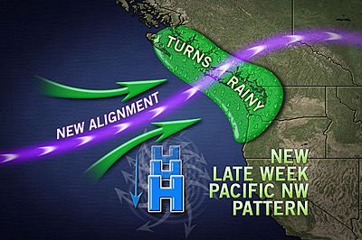
While the Northwest will remain dry through most of the workweek with a stubborn dome of high pressure overhead, it is toward the start of next weekend when umbrellas will once again be needed.
Some rain should return to the Pacific Northwest Friday or Friday night as the high gives way to a series of Pacific storm systems. Heavier rain may then follow and encompass more of the Northwest later in the weekend.
While the first bout of rain will likely not cause any issues, AccuWeather.com meteorologists will be monitoring the second for potential flash flooding issues.
There is also concern that if a soaking rain event does indeed unfold later next weekend airline passengers may experience flight delays as motorists face slower travel.
Snow levels should remain high enough next weekend that motorists will encounter rain, not snow, through the Cascade mountain passes. That could change early during the following week.
Sign up for the Live Science daily newsletter now
Get the world’s most fascinating discoveries delivered straight to your inbox.
The ongoing dry stretch of weather puts motorists throughout the Northwest at risk for another hazard next weekend that some may not consider -- slick roadways from oil residue.
Rain mixing with the oil residue that has been building since the last significant rain event from earlier in the summer threatens to turn roads, including Interstate 5, extremely slippery for a time.
July 20 was the last time Seattle recorded more than a tenth of an inch of rain (0.60 of an inch fell that day). That date for Portland is July 15 when 0.11 of an inch fell, but June 30 is the most recent date the city registered over 0.25 of an inch.
The dry stretch of weather has actually become historic for both Seattle and Portland.
Saturday marked the first time in Seattle's recorded history that 76 days elapsed with a rainfall total of only 0.03 of an inch. The city typically receives nearly three inches during those 76 days.
For Portland, the period from July to September is officially the driest on record. A total of 0.25 of an inch of rain fell during those months at the city's airport, well below the 2.45 inches that is normal.
Portland's driest July to September record was previously set in 1952 with 0.51 of an inch.
October brought no change in the weather with Portland's rain total so far this month registering zero.
Despite the records, the United States Drought Monitor reports that most of Washington and northern Oregon are not enduring a drought or even abnormally dry like the rest of the West. The three large wildfires that have yet to be fully contained across Washington seem to tell a different story.
Firefighters battling these blazes and others across the Northwest are likely eagerly awaiting the impending wet weekend.
© AccuWeather.com. All rights reserved. More from AccuWeather.com.
The only sure thing about weather forecasts is that they’re wildly different all over the planet. Test your knowledge on the wild ranges in temperature, precipitation and more.
Extreme Weather Facts: Quiz Yourself
