This article was provided by AccuWeather.com.
The unseasonable warmth which has been found across much of the Northeast and mid-Atlantic this week will quickly become a distant memory as Sandy approaches and colder air comes marches in from the west.
With Sandy continuing to blast toward the Atlantic coast, AccuWeather.com meteorologists anticipate the storm to make landfall early next week somewhere along the Northeast or mid-Atlantic coast.
At the same time, cold air advancing southeastward into the Ohio Valley, western Pennsylvania and West Virginia will drop temperatures a good 30 to 40 degrees cooler than they were on Thursday.
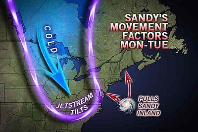
As thousands of East Coast communities get hit with damaging winds, power outages and flash flooding, some of the tropical moisture surging north and west of the storm may begin to interact with this cold air.
A large dip in the jet stream will pull Sandy ashore, and the two will merge together to form a powerful storm system that will affect most of the Northeast and mid-Atlantic.
While there continues to be a large amount of uncertainty with the track of Sandy and how it will interact with the intrusion of cold air from the northwest, it does appear likely that Sandy will bring the first accumulating snow of the season to some of the Appalachians. Unfortunately, it could come with a steep price.
Sign up for the Live Science daily newsletter now
Get the world’s most fascinating discoveries delivered straight to your inbox.
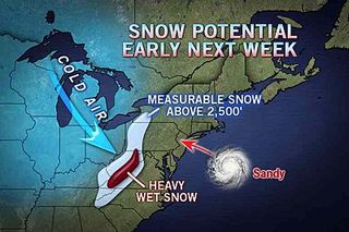
Towns and communities located above 2,500 feet in the Appalachian Mountains from western Pennsylvania down into West Virginia and western Virginia will have the best chance to get snowflakes.
It isn't out of the question that some snow could fall in locations below 2,500 feet as well in these same areas.
According to AccuWeather Meteorologist Randy Adkins, "Given the fact that leaf drop is far from complete, the heavy, wet snow in the high terrain of eastern West Virginia will likely cause damage. This is a tree-crushing snow event should it indeed materialize as forecast."
Strong winds will also aid in knocking down trees with heavy snow on them. Power lines will also be impacted as well which could leave many in the dark for days.
Snow could begin to fall as early as Monday and continue into the middle part of next week.
While exact snowfall amounts are unknown at this time, it is possible that some locations could pick up a rather significant and hefty amount of snow.
AccuWeather.com. All rights reserved. More from AccuWeather.com.
With much of the country experiencing an unseasonably warm winter, fears of climate change come to mind. See how well you understand recent weather, climate and the difference between them.
Weather vs. Climate Change: Test Yourself


