US East Coast Faces Variety of Tsunami Threats


Although the risk is small, tsunamis are possible on the East Coast of the United States from a variety of sources, according to new research.
And as Hurricane Sandy showed, the region is completely unprepared for a major influx of water, said U.S. Geological Survey researcher Uri ten Brink.
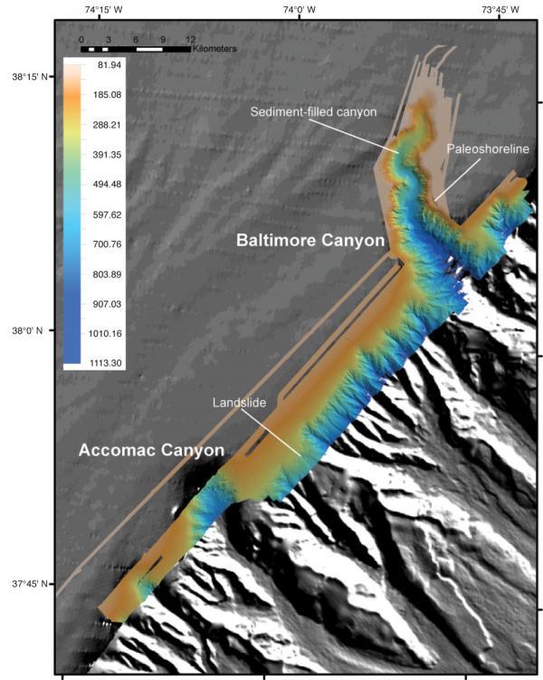
The most likely source for an East Coast tsunami would be an underwater avalanche along the continental slope, according to research presented by ten Brink and others earlier this month at the annual meeting of the Geological Society of America in Charlotte, N.C. Ten Brink also outlined several other possible sources of tsunamis, including earthquakes and even collapsing volcanoes.
Underwater avalanches
An offshore earthquake of magnitude 4.5 or above could cause submarine avalanches and create dangerous tsunamis with waves higher than 26 feet (8 meters), ten Brink told OurAmazingPlanet. Underwater canyons and bays could focus these waves and make them even bigger.
A 7.2-magnitude earthquake off the southern coast of Newfoundland in 1929 caused a large underwater landslide, creating a large wave that rushed ashore and killed 28 people on the island, ten Brink said. The waves were up to 26 feet high until some reached narrow inlets, where they grew to 43 feet (13 m), he said.
While the tsunami was catastrophic for Newfoundland, it created only small waves for most of the U.S. coast and didn't cause any fatalities there. That's typical of tsunamis from submarine landslides: They tend to be large for nearby areas but quickly taper off, ten Brink said.
Get the world’s most fascinating discoveries delivered straight to your inbox.
While this is the only example of a tsunami near the East Coast in recorded history, there are plenty of areas along the continental slope — where the North American continent ends and drops into the Atlantic Ocean basin — at risk for these landslides, ten Brink said. [Natural Disasters: Top 10 US Threats]
Ten Brink and his colleagues are currently taking core samples of sediment from the submarine canyons along the continental slope, to find evidence of past landslides and how often landslides occur, he said. His team has been working for more than five years to map these submarine canyons with sonar to highlight areas most at risk of landslides, he added.
The Puerto Rico trench
The movement of tectonic plates beneath the ocean can create waves that travel much farther than those caused by submarine landslides, because they involve the movement of a much larger volume of water, with longer waves that don't quickly dissipate, ten Brink said. The most dangerous earthquakes are those at subduction zones, where one plate dives beneath another.
While the most infamous subduction zones are found around the Pacific Ring of Fire — such as the one that set off the massive 2011 Japan tsunami — there is indeed a subduction zone capable of creating tsunamis near the East Coast. In the northeast Caribbean, the area called the Puerto Rico trench features a subduction zone.
When the 2004 Indian Ocean tsunami hit, ten Brinks' group received funding from the U.S. government to study the tsunami potential of the Puerto Rico trench. Although its work is still ongoing, his group has found that much of the fault doesn't appear capable of creating an earthquake and tsunami large enough to cause big problems for the East Coast. But a tsunami originating there could cause significant destruction in the Caribbean. [Album: Monster Waves]
University of Puerto Rico researcher Zamara Fuentes, who isn't involved in ten Brinks' research, said one quake in this region in 1918 created a tsunami that killed 116 people on Puerto Rico. Fuentes studies sediment cores around the Caribbean to look for evidence of past tsunamis. Based on historical records, the USGS says 27 tsunamis in the Caribbean have caused fatalities and extensive damage since the 16th century.
Risks across the Atlantic
Another possible source for East Coast tsunamis is the Azores-Gibraltar Transform Fault, off the coast of Portugal. One massive earthquake along this fault in 1755 destroyed most of Lisbon and created a tsunami recorded as far away as Brazil. It was barely noticed on the East Coast, however, ten Brink said. His group has created computer models that suggest underwater mountains west of Portugal helped reduce the impact of this tsunami by slowing the waves and disrupting their movement— and they could do the same thing in the future.
The nearby Canary Islands, off the coast of Morocco, also present a possible hazard. One large volcano on the island of La Palma, called Cumbre Vieja, could erupt, collapse and create a large tsunami capable of reaching the East Coast. A 2001 study suggested this series of events could send a 70-foot (21 m) wave crashing into the East Coast. But ten Brink said that study hasn't held up to subsequent review, and that the wave would be unlikely to exceed several feet in height by the time it reached North America. "I don't see it as a credible threat," he said.
The last possible tsunami source is a slow-moving fault north of Cuba, which has caused earthquakes in the past and possibly could create a tsunami that affected Florida and the Gulf Coast. Due to the current political situation, neither Cuban nor American researchers can conduct research in the area, he said.
To get a good idea of how often tsunamis from this or any source are likely to strike the East Coast in the future, ten Brink and others are trying to peer back in time — but much remains to be discovered. "There are more questions than answers at this point," ten Brink said.
Reach Douglas Main at dmain@techmedianetwork.com. Follow him on Twitter @Douglas_Main. Follow OurAmazingPlanet on Twitter @OAPlanet. We're also on Facebook and Google+.


