Snowy, Colder Pattern for US Leading up to Christmas
This article was provided by AccuWeather.com.
AccuWeather.com long-range meteorologists are monitoring the potential for a colder, snowier pattern across the Plains and the East prior to Christmas.
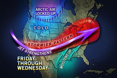
Our forecast tools continue to show the potential for several storm systems that could track from the South to the East from next week through the holiday.
According to AccuWeather.com Chief Meteorologist Elliot Abrams, "There could be one storm or three, but the truth is just as some people may think there isn't going to be a white Christmas, we could have a storm develop right before the holiday to bring millions of people a nice surprise for the holiday."
Are you dreaming of a white Christmas? Check out the probability here.
Another reason that the pattern could turn snowy and colder is because all signs point to a more active southern portion of the jet stream or "storm track."
Generally systems coming out of the South have a high moisture content and strengthen as they lift northward, which in turn, drives cold air farther south.
Sign up for the Live Science daily newsletter now
Get the world’s most fascinating discoveries delivered straight to your inbox.
According to AccuWeather.com Long-Range Meteorologist Joe Lundberg, "The first big event comes out of the southern Rockies late on Friday and Friday night, then cuts across the Plains and tracks through the Great Lakes this weekend."
RELATED:
Climate Origins of a White Christmas
Do the Math: Probability of a White Christmas
How to Forecast a White Christmas
Where to Go for a Guaranteed White Christmas
A track like this would almost certainly bring some snow and ice to parts of the Upper Midwest over the weekend, but amounts and timing are still in question.
Lundberg also states that as this system moves into the East on Sunday and Sunday night, it could bring some snow to parts of New England as well.
Another storm could affect parts of the South and the East during the middle of next week with third system just before the holiday.
At any rate, even though there hasn't been a lot of snow so far this December, the signs of a snowier pattern are showing up.
AccuWeather.com meteorologists are confident that there will be several opportunities for accumulating snow prior to Christmas from the Plains to the East and that will make some folks happy who wish for a white Christmas every year.
The other thing to consider is that a stormier pattern closer to the holiday could lead to increased travel delays both on the roadways and in the air.
Keep checking back with AccuWeather.com as we monitor the potential for several winter storms across the country over the next 7-10 days. Also, check out the climotological probability of a white Christmas and our story about how to forecast a white Christmas.
AccuWeather.com. All rights reserved. More from AccuWeather.com.
