Sneaky Snow Midwest to DC and Delmarva
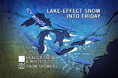
This article was provided by AccuWeather.com.
As a weak storm from Canada scoots eastward, a swath of light snow and flurries will reach from the Ohio Valley to the mid-Atlantic coast into Friday morning.
The weak storm riding a wave of arctic air is the first in a series of systems rolling in from western Canada, known as Alberta Clippers.
The combination of flurries, heavier snow squalls and plunging temperatures can lead to a coating to an inch of snow and slippery roads in some locations of the Midwest.
Highways of concern across the north include I-70, I-80, I-90 and I-94. Across the south include I-64, I-75, I-79 and I-81.
Roads could be slippery throughout Thursday from Detroit to Indianapolis, Louisville, Ky. Cincinnati, Cleveland, Buffalo, Pittsburgh and Charleston, W.Va.
Just enough snow can fall to coat roads and make for icy spots into Friday morning.
Sign up for the Live Science daily newsletter now
Get the world’s most fascinating discoveries delivered straight to your inbox.
A multiple vehicle crash caused fatalities in the Detroit area Thursday morning. Snow showers and a freeze-up likely contributed to the crash.
The same system will ride the push of cold air to the East Coast Thursday night into Friday morning.
A bit of snow will race across Tennessee Thursday night and could coat the ground in Nashville and Knoxville.
A couple of inches of snow can fall in parts of the Appalachians from near the Tennessee/North Carolina boarder to western Pennsylvania.
While the Appalachian mountains will screen out much of the snow from the Midwest, it can still bring enough for icy spots and areas of slippery travel for the morning drive Friday east of the mountains.
Metro areas that could experience wintry problems include Washington, D.C.; Baltimore, Md., Dover, Del., Philadelphia and perhaps as far south as Richmond, Va.
The recent drenching rain has washed away any treatment on the roads from earlier in the month.
Even in areas where there is no appreciable snowfall, runoff across some secondary roads can freeze.
Through the end of the week, bands of heavy snow will continue to fall downwind of the Great Lakes. Some of the snow belts to east and southeast of the water bodies can pick up a couple of feet of snow.
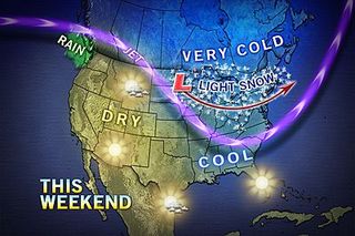
A somewhat larger and stronger Alberta Clipper is forecast to roll across the Midwest and Appalachians this weekend.
The storm has the potential to turn the corner upon nearing the Atlantic Coast and grabbing moisture at the last minute. Due to the larger size and potential to gain more strength and moisture, the system could bring a larger swath of snow and more substantial snow amounts.
AccuWeather.com. All rights reserved. More from AccuWeather.com.
The weather is getting stranger, right? Well, for the most part no, scientists say, but humans often think so when a strange event does occur. So here’s your chance to prove how much you known about weather oddities.
Weird Weather: One Strange Quiz
