What's Causing All This Snow?
A dangerous storm could dump more than 2 feet of snow in some parts of the Northeast this weekend, according to weather forecasts.
But what's behind the blizzard that's forecast to be one of the biggest snowstorms in decades for some cities?
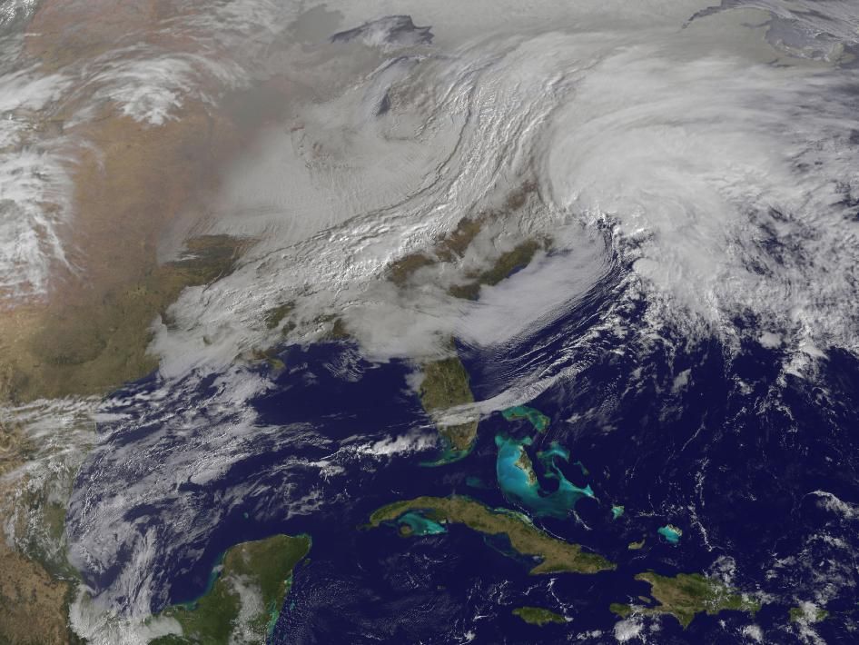
A collision between two powerful weather systems is the snowy culprit.
In the past week, cold Arctic Air from western Canada sailed across the continent along the jet stream, straight for New England. The weather phenomenon is called an Alberta Clipper, for the frigid air that originates in Canada's Alberta province and for the fast clipper ships that once sped across the seas, according to AccuWeather.com.
Moisture for rain and snow arrived with a low-pressure system moving up the Gulf Coast from the South.
When and how the two systems slam into each other determines whether the Northeast is buried by snow or simply gets a light dusting of flakes. Some forecasts show the two systems colliding off the coast of Massachusetts, near Cape Cod, which would bring the extreme snowfall and gusting winds worrying residents across the region. However, other weather models show the storms merging further south, which would push the brunt of the storm's energy out to sea — meaning less snowfall on land.
But the odds of an easy weekend seem are diminishing by the hour, as NASA satellites track the two systems merging over the East Coast.
Sign up for the Live Science daily newsletter now
Get the world’s most fascinating discoveries delivered straight to your inbox.
Heavy snowfall
Forecasters this morning are calling for dangerous blizzard conditions, with hurricane-force winds gusting up to 70 miles per hour (112 kilometers per hour). [What is a Blizzard?]
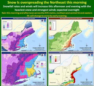
"The heaviest snow is forecast to fall across parts of eastern Massachusetts, Connecticut and Rhode Island, where snowfall amounts higher than 2 feet (60 centimeters) are possible," the National Weather Service (NWS) said in a statement. "The storm should reach its peak intensity early Saturday morning just east of Cape Cod."
Boston could get 2 to 3 inches (5 to 8 cm) of snow per hour, the same quick-building snowdrifts that paralyzed the city 35 years ago. The "Great Blizzard" of 1978 dumped 27 inches (68 cm) of snow in one day, leaving several people dead. About 29 inches (74 cm) of snow are forecast to fall in Boston during this storm's peak.
In New York, 10 to 14 inches (25 to 35 cm) of snow are expected to pile up in the region by Saturday afternoon.
How much snow?
When flakes fall from the sky, employees from the National Weather Service use a decidedly old-fashioned technique to measure snowfall.
The tracking tools? A white "snowboard" and a stainless steel ruler. (The white board is cooler, because it absorbs less heat from the sun.)
An NWS meteorologist takes several measurements on the board and then averages them to come up with a snowfall amount. If strong winds are blowing snow off the board, she will use the local weather office's rain gauge instead. A rain gauge has a tall plastic tube that collects and protects snow from frigid wind.
The National Science Foundation is funding efforts to develop more accurate methods to quickly measure snow accumulation.
Scientists at the National Center for Atmospheric Research (NCAR) in Boulder, Colo., have developed an instrument that uses laser pulses to measure 10 feet (3 meters) or more of snow with an accuracy as fine as a half-inch (1.2 cm) or better.
And in 2014, NASA will launch the Global Precipitation Measurement satellite, the first designed to measure falling snow from space. "Snow is notoriously hard to measure as it falls," Walter Petersen, a scientist at NASA's Wallops Flight Facility in Virginia, said in a statement. "Snowflakes contain varying amounts of air and water, and they flutter, wobble and drift as they leave the clouds."
During massive winter storms, the heaviest snowfall can occur in surprisingly narrow bands, on a smaller scale than current weather networks can see, according to the National Snow and Ice Data Center (NSIDC).
Variations in snow depth along streets and within neighborhoods are caused primarily by wind during and after the storm, and by melting after the storm, the NSIDC said. On a larger scale, towns in the middle of a storm track may be buried by snow, while cities along the edge of the storm will see only light flurries.
Reach Becky Oskin at boskin@techmedianetwork.com. Follow her on Twitter @beckyoskin. Follow OurAmazingPlanet on Twitter @OAPlanet. We're also on Facebook and Google+.

