Only in California: Daily Earthquake Forecasts

Geologists have constructed a model that calculates the probability of an earthquake for a given day and location in California, much like a meteorologist announces today's chance of rain.
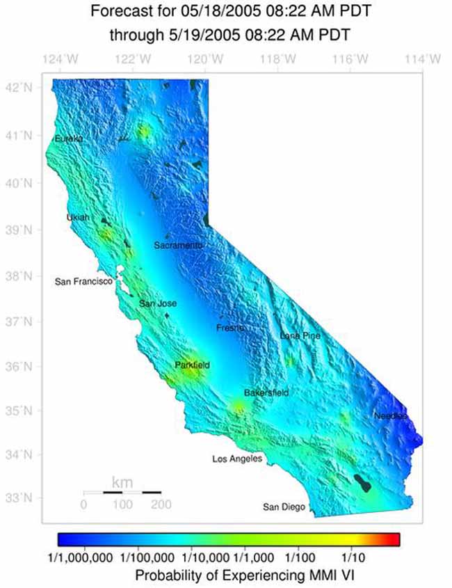
A color-coded probability map is available on the Internet.
When an earthquake strikes, follow-up temblors, or aftershocks, are quite possible. Matthew Gerstenberger of the U.S. Geologic Survey and colleagues have used theories for how earthquakes cluster to determine the likelihood of seismic activity in a certain location over a 24-hour period.
The seismic forecasts incorporate a background model - based on the history of known fault lines - with data on recent seismic activity. Currently only available for California, geologists hope to expand the forecasts to other earthquake-prone areas.
Updated every hour, the map gives the probability of an event shaking an area with Modified Mercalli Intensity VI (six) or greater, which is enough to cause plaster to crack and windows to break. For the most part, the daily forecasts go from one-in-a-million to one-in-a-thousand.
"You would only see a red spot [corresponding to more than one in 10] after a large earthquake has occurred," Gerstenberger told LiveScience in a telephone interview.
Following a main shock, the probability of aftershocks decreases with time. But surprisingly, some past events still cast a menacing shadow over the maps.
Get the world’s most fascinating discoveries delivered straight to your inbox.
"We still see a slight increase in probability from Loma Prieta," Gerstenberger said. The Loma Prieta earthquake struck in 1989 with a magnitude of 6.9.
Magnitudes are an overall measure of the energy released in a quake, whereas intensity quantifies the amount of shaking in a particular area.
Other prominent temblors that still affect the forecasts are the 1992 Landers and 1999 Hector Mine earthquakes, with magnitudes 7.3 and 7.1, respectively.
To demonstrate their model's accuracy, the researchers computed forecasts for the years between 1988 and 2002. As detailed in the May 19 issue of Nature, the number of aftershocks in the model matched what was actually observed over this time period.
Gerstenberger did not expect people to check the earthquake forecast everyday, but he hoped they would educate themselves about the elevated hazard after a significant event. The forecasts could also help relief efforts in planning the response to a major quake.
"The public is accustomed to seeing probability numbers given for weather forecasts, and seismologists are fortunate in now being able to provide them for earthquakes," wrote Duncan Agnew of the University of California, San Diego, in an accompanying commentary in the journal.
A live version of the color-coded map can be viewed here.
Related Stories
- Deadliest Earthquakes in History
- Central US Warned of Larger Earthquakes to Come
- Large California Earthquake Possible Within 30 Years
- Crumbled Tombstones Lead to New View of 1906 Earthquake
- New Method Promises Better Earthquake Prediction
- March is Earthquake Month, and Other Shaky 'Facts'
- Earthquakes Stopped, But Only In Lab
Today's Forecast ...
Credit: USGS
 Live Science Plus


