Amazing Images: Volcanoes from Space
Klyuchevskaya Volcano
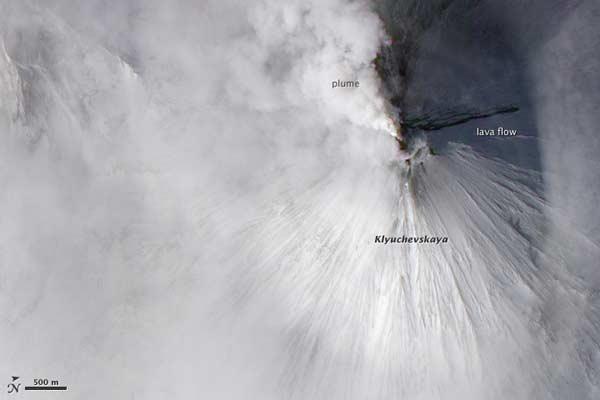
The snow-covered Klyuchevskaya Volcano on Russia's Kamchatka Peninsula part of the highly volcanically and seismically active Pacific "Ring of Fire." Klyuchevskaya the largest active volcano in the Northern Hemisphere is seen here erupting in March 2010.
The volcanic plume, low-lying clouds and snow are all white in the image taken by NASA's Earth Observing-1 satellite, while a lava flow on the shadowed (northern) flank of the mountain is nearly black.
The 15,863-foot (4,835-meter) high volcano has erupted nearly continuously since it first formed about 6,000 years ago.
Anak Krakatau
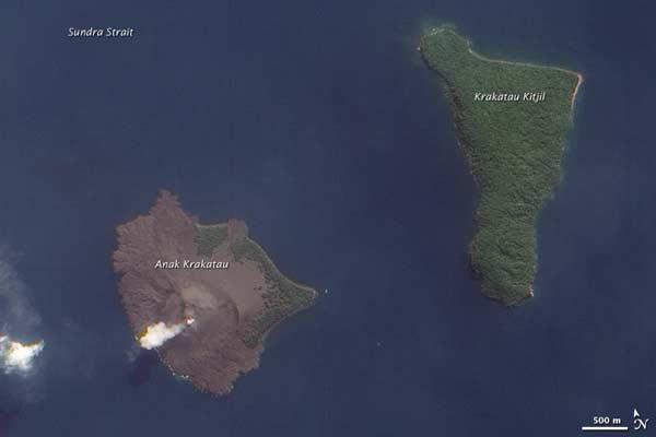
Anak Krakatau ("Son of Krakatau") is the volcanic island that formed in the caldera of Krakatau (also written Krakatoa), which erupted catastrophically in 1883. It sits in the Sunda Strait between the Indonesian islands of Java and Sumatra.
That massive eruption spewed huge amounts of ash and pumice into the sky and could be heard thousands of miles away. Tsunamis spawned by the eruption inundated nearby parts of Indonesia, killing some 36,000 people one of the most devastating eruptions in history.
Anak Krakatau arose less than 50 years after the 1883 eruption and has seen frequent rumblings and outbursts since then.
Eyjafjallajökull Volcano
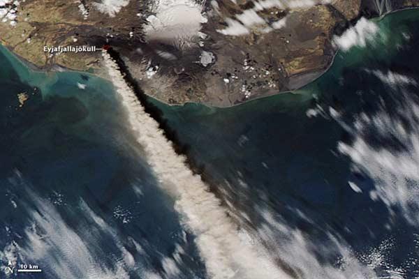
Eyjafjallajökull began pumping ash into the atmosphere on March 20, 2010. As the plume was blown across Europe, it severely hampered air travel while it also produced spectacularly red sunsets.
How long Eyjafjallajökull will continue to erupt for is up in the air, though in the past a single eruption has lasted for years. The inter-connected magma chambers of many of Iceland's volcanoes give them a unique dynamic, and Eyjafjallajökull connects to another nearby volcano, Katla, which has a history of erupting not long after its neighbor.
The volcanoes of Iceland are what created the island about 70 million years ago. The small European nation is situated on the Mid-Atlantic Rise, a seam in the Earth's surface under the North Atlantic Ocean where the Eurasian and North American plates slide apart. Magma upwells along the rise and spreads out to create new crust. Iceland is thought to sit on a pocket of magma that created the island and continues to fuel its many volcanoes today.
Mount Etna
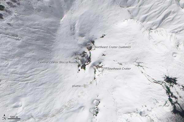
Here, Sicily's Mount Etna Italy's most active volcano sits mostly quiet in March 2010, though thin brown and white plumes rise above the Central Crater (also known as Bocca Nuova) and the Northeast Crater.
This shield volcano rises 10,925 feet (3,330 meters) high and has one of the longest documented records of eruption, dating back to 1500 B.C.
Etna's last eruption ended in June 2009, according to the Istituto Nazionale di Geofisica e Vulcanologia Sezione di Catania.
Kilauea's Halema'uma'u Crater
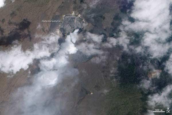
A lava-filled pit set inside Kilauea's Halema'uma'u Crater emitted a plume of steam, ash and sulfur dioxide earlier this year as seen in this image from NASA's Earth-Observing-1 satellite.
Halema'uma'u Crater is itself a crater in the larger Kilauea Caldera the smaller pit opened up in its southwestern wall on March 19, 2008. Volcanic emissions have continued almost uninterrupted since, punctuated occasionally by violent explosions of ash and fragments of rock torn from the crater walls.
On September 5, 2008, scientists at the Hawaii Volcano Observatory discovered a lava lake inside the pit.
Mount St. Helens
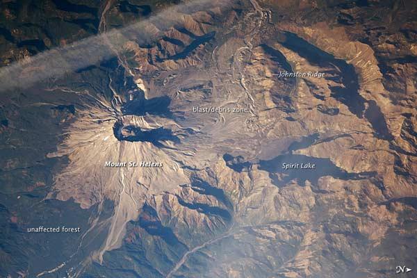
Mount St. Helens blew in a cataclysmic eruption on May 18, 1980. That eruption blew ash high into the atmosphere, where it was picked up and carried for thousands of miles.
The eruption killed 57 people and devastated the local landscape, which is still recovering more than 30 years later. During the eruption, the north flank of the volcano slid away in the largest landslide in recorded history.
The Mount St. Helens eruption taught scientists much about looking for warning signs of eruptions at it and other volcanoes. The volcano rumbled back to life in 2004, though the eruptions from that episode were far milder than the 1980 disaster.
Jebel at Tair
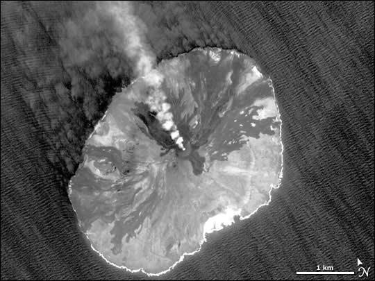
Jebel at Tair, a small volcanic island in the Red Sea, erupted in late September 2007. A plume of smoke from the volcano was caught in this Nov. 8, 2007 image taken by NASA's EO-1 satellite.
The dark stains on the volcano's slopes are evidence of earlier lava flows.
This stratovolcano sits midway between Yemen and Eritrea and is made up of alternating layers of hardened lava, solidified ash and rocks ejected from eruptions.
Sign up for the Live Science daily newsletter now
Get the world’s most fascinating discoveries delivered straight to your inbox.
Submarine Eruption in Tonga Islands
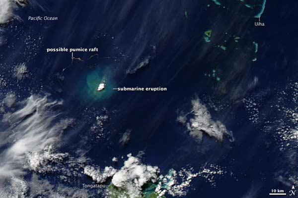
This submarine eruption, captured by NASA's Aqua satellite, occurred in the Tonga Islands of the South Pacific in mid-March 2009.
The area around the eruption appears bright blue-green, likely resulting from ash and other volcanic debris suspended in the water. The brilliant white patch may result from vapor released by the volcano.
Northwest of the eruption, a ribbon of brown is likely a pumice raft pumice is highly porous and floats on water. When a lot of pumice if thrown from an erupting volcano it can bunch together into a "raft." Just such a raft occurred after an August 2006 eruption.
Ol Doinyo Lengai
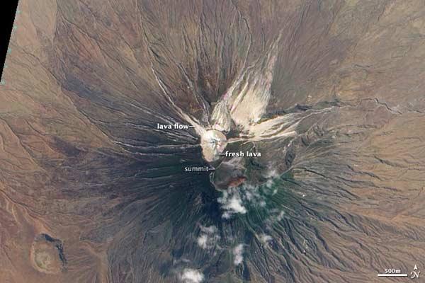
Ol Doinyo Langai in Tanzania is the only volcano in the world that erupts what is called natrocarbonatite lava, which is rich in calcium, sodium and potassium, but low in silica (silicon dioxide).
>The lava of Ol Doinyo Lengai is extremely cool (932 to 1,112 degrees Fahrenheit, or 500 to 600 degrees Celsius, compared to 2,120 F, or 1,160 C, for typical basaltic lava) and relatively fluid.
The volcano switches from periods where it erupts liquid lava that pools into lava lakes to explosive periods where it builds large ash cones. In the image, acquired with NASA's Earth-Observing-1 satellite, dark areas on the crater floor are recent lava flows (days to weeks old), while the beige and white regions are older lava that has reacted with rain and moisture in the atmosphere.
Manam Volcano
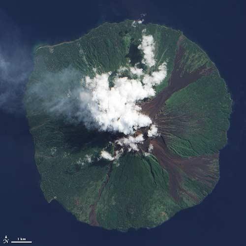
Manam volcano is one of Papua New Guinea's volcanoes. In this June 28, 2009, image, a faint plume rises from the volcano.
Manam is a stratovolcano that measures 6 miles (10 kilometers) across. Frequent historical eruptions, typically of fairly mild character, have been recorded at Manam since 1616, according to the Smithsonian's Global Volcanism Program.
Eruptions from the volcano have caused casualties, including 13 deaths from a pyroclastic flow in December 1996, and four deaths from a mudflow in March 2007. Large eruptions in late 2004 forced the evacuation of the entire island.
Turrialba Volcano
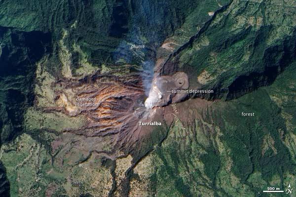
A translucent plume of smoke rises from Turrialba Volcano, located in central Costa Rica.
The 10,960-foot (3,340-meter) summit of the volcano appears grey and brown in this image taken by NASA's Earth-Observing-1 satellite because it is barren. Five major explosive eruptions have occurred at Turrialba during the past 3,500 years.
While much of the forest and fields around the volcano appear a verdant green, some vegetation shows signs of damage. Since 2007, frequent acid rain showers caused by activity at the volcano have killed or damaged much of the vegetation to the southwest of the summit, leaving the area brown and orange.

Andrea Thompson is an associate editor at Scientific American, where she covers sustainability, energy and the environment. Prior to that, she was a senior writer covering climate science at Climate Central and a reporter and editor at Live Science, where she primarily covered Earth science and the environment. She holds a graduate degree in science health and environmental reporting from New York University, as well as a bachelor of science and and masters of science in atmospheric chemistry from the Georgia Institute of Technology.


