Colin Becomes Third Named Atlantic Storm of Season

Tropical Storm Colin became the third named storm of the 2010 Atlantic hurricane season earlier today.
The U.S. National Hurricane Center (NHC) reported that Tropical Depression Four strengthened into a tropical storm early in the day. A tropical storm has winds that blow at least 39 mph (63 kph) and reach up to 73 mph (118 kph).
As of 11:00 a.m. EDT on August 3, Colin was located about 840 miles (1,355 kilometers) east-southeast of the Leeward Islands. Colin had maximum sustained winds of 40 mph (65 kph).
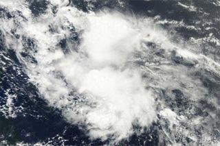
The Moderate Resolution Imaging Spectroradiometer (MODIS) on NASA's Terra satellite captured this natural-color image of Tropical Storm Colin at 9:40 a.m. EDT (13:40 UTC) on Aug. 3. Although the storm hints at the comma shape characteristic of tropical storms, it lacks a distinct eye, a standard feature of a well-developed hurricane.
Current projections have Colin strengthening somewhat and heading to the northwest for several days before turning northward. The storm isn't currently predited to hit land anywhere.
Colin follows behind the first two named storms of the season, Hurricane Alex and Tropical Storm Bonnie. Alex hit Belize on June 26 and later made landfall along the coast of Mexico. The storm put a pause on efforts to stem the Gulf oil spill and had responers worried it could spread the oil, though the storm ended up steering clear of the spill area.
Bonnie made landfall in southeast Florida on July 23, then later emerged into the Gulf of Mexco where it made a beeline for the oil spill. Bonnie petered out before it hit the coasts of Mississippi and Louisiana.
Sign up for the Live Science daily newsletter now
Get the world’s most fascinating discoveries delivered straight to your inbox.
The 2010 hurricane season is predicted to be above average in terms of storm activity. While the Atlantic and Gulf have been relatively quiet so far, August and September are typically the most active months of the season.


