Super Typhoon Megi Hits the Phillippines

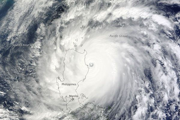
Super Typhoon Megi approached and made landfall in the northeastern Isabela Province of the Philippines today (Oct. 18).
NASA's Terra satellite was able to take a snapshot of the storm as it was bearing down on Palanan Bay as a "super typhoon" with category 5 strength. As of 8:00 a.m. local time, the storm had sustained winds of 167 miles (268 kilometers) per hour.
Spanning more than 370 miles (600 kilometers) across, Megi which means catfish in Korean was the 15th tropical storm and seventh typhoon of the season in the western Pacific Ocean. It was the most intense tropical cyclone of the year to date. (Tropical cyclone is the all-encompassing term for tropical storms, hurricanes and typhoons, all of which are the same type of phenomenon, just occurring in different ocean basins.)
News reports indicated at least one death and an unknown number of injuries, as power and communications were cut off to more than 90 percent of the Isabela and Cagayan provinces. Officials are also worried about damage to the rice crop, a staple of the national diet.
The storm had grown to "super" typhoon status on Oct. 16, and wind speeds peaked at an estimated 178 mph (287 kph) while the storm was still over the Pacific Ocean the next day. Megi began to downgrade as it moved onshore on Oct. 18 and crossed over the Sierra Madre mountain range.
Forecasters were predicting that the storm would continue moving west and north, entering the South China Sea and re-intensifying before a potential landfall in China or Vietnam later this week.
Sign up for the Live Science daily newsletter now
Get the world’s most fascinating discoveries delivered straight to your inbox.


