Hurricane Tomas Spotted Moving Through Windward Strait

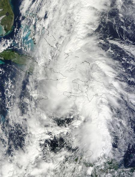
The center of Hurricane Tomas was moving through the Windward Passage today (Nov. 5) at 2 p.m. ET, and NASA's Terra satellite captured a visible image of the rainmaker.
Located in the Caribbean Sea, the Windward Passage is a strait located between eastern Cuba and the northwest of Haiti.
In satellite imagery, Tomas' convection (rapidly rising air that forms the thunderstorms that power the tropical cyclone) was described by the National Hurricane Center as "looking a little ragged" hinting that they are weaker and possibly more disorganized, due to the interaction with the mountains of Hispaniola, the island that is home to Haiti and the Dominican Republic.
At 2 p.m. ET, Tomas's center was 75 miles (120 km) southeast of Guantanamo, Cuba, and 140 miles (225 km) northwest of Port Au Prince, Haiti's capital.
Tomas' maximum sustained winds were still near 85 mph, and some strengthening is still possible today, but wind shear is expected to weaken Tomas thereafter.
The rains from Tomas lashing Haiti could increase the chances of dangerous landslides occurring in the country, which already has destabilized soils from the 7.0 magnitude earthquake that struck in January.
- Without its Trees, Haiti Laid Bare to Hurricane's Impact
- What U.S. Cities are Most Vulnerable to Hurricanes?
- Surprisingly, Hurricanes Avoid U.S. Landfall in 2010
Sign up for the Live Science daily newsletter now
Get the world’s most fascinating discoveries delivered straight to your inbox.


