Severe Storms, Tornadoes Hit Southeastern U.S.
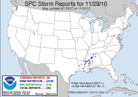
Severe storms whipped across the southeastern United States last night, with tornadoes reported in three states, according to the Storm Prediction Center.
The month of November, the so-called second tornado season, started slow but is ending with a bang. Last night's massive storm system may have spawned eight tornadoes, according to preliminary reports. Central Mississippi was hit hard, with 11 reported injuries, according to the Mississippi Emergency Management Agency and the Storm Prediction Center. Tornadoes were also reported near Atlanta, La., and Livingston, Mo.
In Yazoo County, Miss., where just seven months ago a mile-long, EF4-strength tornado touched down, severe storms knocked out power for thousands and downed trees.
The storms continued to push east Tuesday morning (Nov. 30) and tornado warnings were issued across parts of Mississippi, Alabama, Georgia and Florida. A tornado warning is issued by the National Weather Service if a funnel cloud has been spotted or a tornado is imminent.
Earlier this month, rare tornadoes hit parts of the Midwest. A twister hit Caledonia, Ill. the first November tornado to hit Illinois in more than five years. In Wisconsin, the first November tornado in more than 39 years which boasted an EF1 strength rating struck Walworth County. [Related: What Day Had The Most Tornado Strikes?]

Fall tornadoes often come as a surprise because the main tornado season runs from spring to early summer, but tornadoes can form under a variety of conditions and strike during fall and winter.
Fall and spring are both transitional periods when masses of warm and cool air are more likely to collide and create the thunderstorms that can spawn tornadoes.
Sign up for the Live Science daily newsletter now
Get the world’s most fascinating discoveries delivered straight to your inbox.
Tornadoes form where warm moist air is trapped underneath a layer of cold, dry air. The strongest tornadoes often form when the wind at around 10,000 feet (3,000 meters) above the ground blows in a different direction than the surface wind. In the spring, warm air rising in the storm system hits this so-called wind shear and is pushed from a vertical motion to a horizontal motion, creating a strong rotation.
In the fall, wind shear returns across the United States as the jet stream a fast but narrow air current moves back south after a summer spent up north. Warm, moist air is still at the surface.
The big difference between the spring and fall tornado seasons is that the temperatures in that top layer are typically a little warmer for a given surface temperature in the fall than in the spring. As a result, the atmosphere does not have as much potential energy and therefore fewer storms strike during the fall.
November tornadoes tend to be more common in the lower Mississippi valley, including states such as Louisiana, Arkansas and Mississippi. This is because moist air from the Gulf Coast can more easily reach these states, while it may be blocked from spreading elsewhere, Robert Henson, meteorologist with the National Center for Atmospheric Research in Boulder, Colo., told OurAmazingPlanet.
- The World's Weirdest Weather
- In Images: Storm Chasing Scientists
- Skyscraper Storms: 7 Big City Tornadoes
Reach OurAmazingPlanet staff writer Brett Israel at bisrael@techmedianetwork.com. Follow him on Twitter @btisrael.


