Tin Bider Crater Has Tricky Topography

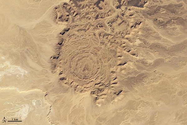
Geologists estimate that the Tin Bider Crater, a 4-mile-long (6 kilometers) crater in Algeria was formed in the last 70 million years. It can be seen stretching across the desert in this Dec. 3 image taken by NASA's EO-1 satellite.
While Algeria's coast enjoys a Mediterranean climate with mild, wet winters, the interior of the country's terrain is mostly high desert where mountains and impermanent rivers interrupt sand seas. Tin Bider sits in this dry, rugged terrain at the southern end of a range of hills.
In this image, the desert surface appears in shades of tan, camel, beige and brown. Sunlight leaves north-facing slopes in shadow. In fact, the angle of the Sun can play an optical illusion: While the crater seems to sit at a lower elevation than the surrounding land, it doesn't. The angle of sunlight is from the south, and Tin Bider actually rises above the land to the south, east and west.
The elevated position and concentric rings of Tin Bider suggest that it has the structure of complex impact crater. Complex craters are distinguished by structures such as central peaks, or an inner 'peaked' rings, terraced rim walls and outer concentric faulted zones. A simple crater is what most people associate with the word crater; it is a circular bowl shape with an uplifted rim.
The rings that make up Tin Bider may have been the result of terraces composed of rock that collapsed after the impact, but it is also possible that the underlying geology where the impact occurred might have played a role.
- Image Gallery: Earth's Impact Craters
- Meteor Crater: Experience an Ancient Impact
- Eye of Africa Peers Up from the Sand
Sign up for the Live Science daily newsletter now
Get the world’s most fascinating discoveries delivered straight to your inbox.


