Australia's Lake Eyre Basin Goes from Dry to Wet
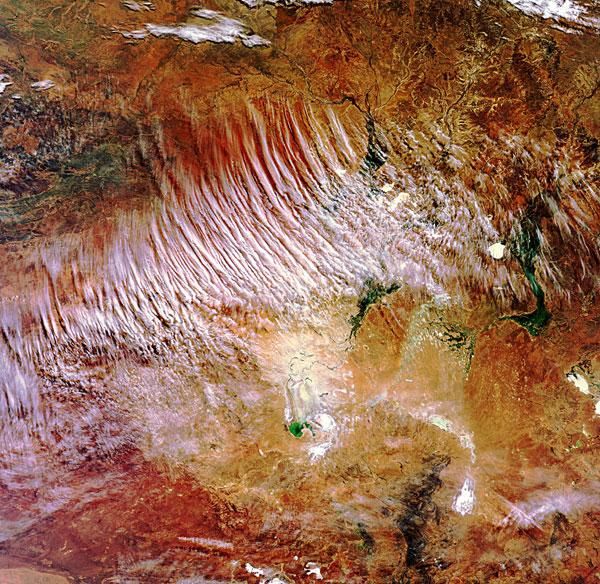
Lake Eyre Basin, one of the world's largest internally draining systems lies in the heart of Australia.
This image, taken by the European Space Agency's Envisat satellite, shows the basin among the crimson soil of the country's Red Center.
The Red Center is the colloquial name given to the southern desert region of the Northern Territory in Australia.
The basin covers about 463,322 square miles (1.2 million square kilometers), making it roughly the size of France, Germany and Italy combined. The basin covers ground in multiple territories, including large portions of South Australia (bottom), the Northern Territory (upper left) and Queensland (upper right) and a part of western New South Wales (bottom right).
Usually the rivers in this arid, barren, red region are dry, but a series of rain events across the country's central deserts has turned the vast floodplains around Lake Eyre into wetlands.
The white circle in the center right of the image is Lake Yamma Yamma, which is a classic example of an Australian feature known as a 'floodout,' a lake that fills during floods and then slowly drains as the flood subsides. The lake is fed by Coopers Creek River to its east; Coopers Creek River is itself a combination of the Thomson and Barcoo Rivers.
Red earth from the Simpson Desert, the world's largest parallel sand dune system, is visible across the top of the image. The desert straddles the corners of South Australia, Queensland and the Northern Territory.
Sign up for the Live Science daily newsletter now
Get the world’s most fascinating discoveries delivered straight to your inbox.
The vast red sands of the Yellabinna region and the dark sediment of the Flinders Ranges mountain range highlight the region's varied landscape.
- The Harshest Environments on Earth
- Observing Earth: Amazing Views From Above
- 101 Amazing Earth Facts


