
Looking Back: Images from the Haiti Earthquake
Port-au-Prince from above
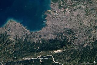
This regional view of Port-Au-Prince, Haiti, taken by NASA's Earth Observing-1 satellite on Jan. 15, 2010, illustrates some of the physical obstacles that complicated the job of aid workers in the aftermath of the earthquake that struck along the Enriquillo-Plaintain Garden Fault south of the city on Jan. 12.
The capital city is densely populated and densely built, with little open space apparent amid the gray pavement and buildings. With debris filling the streets, it was difficult for vehicles to move aid supplies and the wounded.
The single port through which large cargo ships can approach the city (image center) was damaged, and the city's only landing strip (top right) was overwhelmed by the number of flights trying to land and take off.
Potential landslides from quake
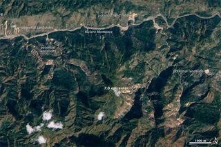
Because of the massive deforestation on Haiti's steep mountain slopes, the country is prone to landslides, usually from torrential tropical rainfall. But the 7.0-magnitude earthquake may have also triggered landslides and shifted earth so that landslides are more likely in the future.
This true-color image, taken by the EO-1 satellite on Jan. 15, highlights potential landslides around the earthquake's epicenter, which is near the center of the scene. The landslides are bright streams of exposed earth that contrast with the dark green plants and tan soil around them. Some, but not all, of the potential landslides are labeled.
Landslides on denuded hilltops
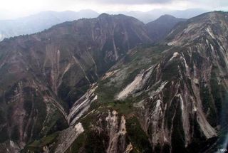
The landslides possibly caused by the quake can be seen in a closer view here.
Vegetation, with all its roots, helps hold soils in place. Without it, soils are more prone to sliding down slopes. Earthquakes can exacerbate this tendency by loosening soils.
Relief ships
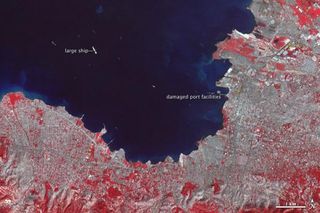
Ships carrying relief supplies and aid were streaming into Port-au-Prince, Haiti, when this false-color image was taken by a thermal imager on NASA's Terra satellite on Jan. 21. The city itself is gray, plant-covered land is red and the ocean is dark blue.
The city's badly damaged port was able to open one pier on Jan. 20. That pier was the city's south pier, the narrow strip that juts out into the water in this image. Part of the pier collapsed in the earthquake, but the remaining structure was just stable enough to support a single truck offloading supplies from docked ships, CNN reported at the time.
Tiny streaks of white in the dark blue water are ships. The largest ship in the scene may be the USNS Comfort, a 273-meter- (894-foot-) long U.S. Navy hospital ship that was taking patients by helicopter until a pier could open up, according to Business Week.
Quake damage seen from ISS
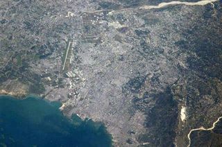
An Expedition 22 crew member onboard the International Space Station took this image of the 260-year-old city of Port-au-Prince on Jan. 18, 2010.
Uplifted coral
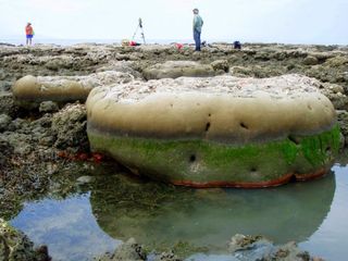
This microatoll coral head was uplifted at the coast by the earthquake.
This previously submerged coral head was uplifted approximately 26 inches (65 centimeters) during the earthquake. At the time of the photo, high tides reached approximately to the highest level of green algae.
Building damage
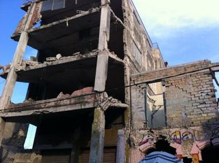
Much of the death and damage in Haiti was the result of infrastructure that was too weak to withstand such a powerful earthquake.
An 8.8-magnitude quake that struck Chile a little over a month later was stronger but ultimately did less damage because that country had buildings and other infrastructure built to withstand the temblors that frequently strike the seismically active country.
Sign up for the Live Science daily newsletter now
Get the world’s most fascinating discoveries delivered straight to your inbox.
Rubble in the streets
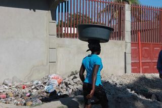
Rubble from damaged buildings and other structures remained on the streets even when this photo was taken, nearly a year after the quake on Dec. 30, 2010.
Tent cities
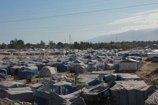
One of the many tent cities that arose after the quake is seen here. Rebuilding after the earthquake is expected to be a long and difficult one, given the poverty of the country and the sheer magnitude of the destruction.


