Snow Hits New England Area, Again

A classic Nor'easter plowed up the East Coast of the United States on Jan. 12, 2011, dumping heavy snow on New England states for the third time in three weeks, according to a NASA statement. The storm began developing late on Jan. 11, as a snow-making system that had hit the southern U.S. rode up the Atlantic seaboard and merged with another system crossing from the Midwest.
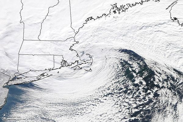
The Moderate Resolution Imaging Spectroradiometer (MODIS) on NASA's Terra satellite took this photo-like image at 10 a.m. Eastern Standard Time on Jan. 12, when the storm was centered over southern New England.
The storm had a distinctive comma shape reminiscent of a hurricane that forms when air circles around a low-pressure center (centered over Cape Cod, Mass., in the image). Higher, thinner clouds swept around the south side of the storm, circling counterclockwise around the center. These lines of clouds formed when frigid winds blowing off the land chilled the moist ocean air.
The air circling the storm center from the north came in off of the ocean, where it picked up moist air. The dense clouds on the north and west side of the storm carried intense snow.
The places where these clouds dominate the image Maine, New Hampshire, Vermont, eastern New York, Massachusetts, Connecticut, and Rhode Island were hit hard with snow falling as fast as 3 inches an hour, according to the National Weather Service. More than 24 inches (61 centimeters) of snow had fallen in parts of New England by the evening of Jan. 12.
The powerful snow storm brought gale-force winds (over 39 miles per hour, or 63 kilometers per hour) to many coastal areas and claps of thunder in others. Blizzard conditions snowstorms with visibility less than one-quarter mile and winds at gale force for more than three hours developed in parts of Massachusetts and Connecticut.
The strong winds combined with heavy snow left more than 100,000 people without electric power, and led to the shutdown of parts of Interstate 95 and northeastern railroad service. Bradley International Airport near Hartford, Connecticut, set a one-day record with 22.5 inches (57 centimeters) of snow.
Sign up for the Live Science daily newsletter now
Get the world’s most fascinating discoveries delivered straight to your inbox.


