Tropical Depression Anthony Bears Down on Australia

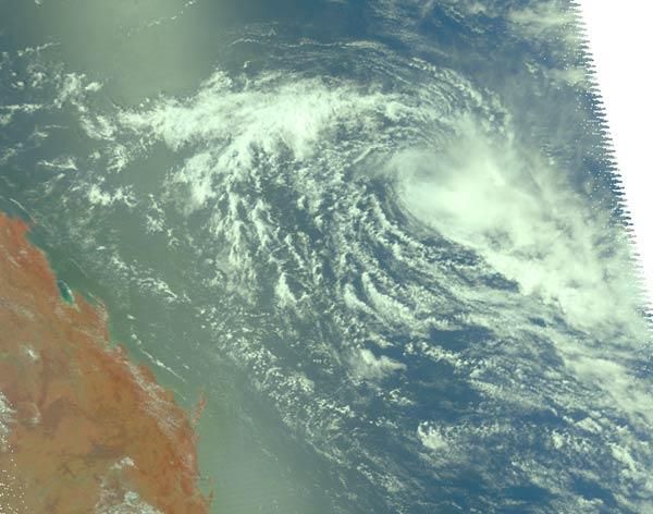
NASA's Aqua Satellite captured a visible image on Jan. 26 of the former Tropical Storm Anthony, now weakened to a tropical depression, but forecasters aren't counting Anthony out yet.
Despite its weakened condition Anthony continues to move west toward Queensland, Australia and into a more favorable area for sustaining a tropical cyclone.
At 0600 UTC (1 a.m. EST) on Jan. 26, Anthony had progressed west and was now about 455 nautical miles west-northwest of Nomeau, New Caledonia. Maximum sustained surface winds are estimated at 28 mph to 34 mph (46 kph to 55 kph) meaning that Anthony is still at tropical depression status.
The images reveal that the storm has a well-defined low level circulation center, although dry air is now wrapping into Anthony's northern quadrant. Dry air saps the moisture that creates the thunderstorms that power a tropical cyclone. Generally, the storm's convection (rapidly rising air that creates those thunderstorms) is weak throughout the storm, and only isolated strong areas of convection appear in the southeastern quadrant. That may change in the next day or two, however, as Anthony moves into an area more conducive to maintaining a tropical cyclone.
Vertical wind shear (winds that can weaken a tropical cyclone) has lessened and sea surface temperatures are warm enough to sustain and strengthen a tropical cyclone. Computer forecast models have shown forecasters at the Joint Typhoon Warning Center that as the system tracks westward toward Australia, there is a fair chance that Anthony will regenerate or re-strengthen in the next 24-36 hours. Forecasters in Queensland, Australia, already plagued by massive flooding from relentless rains , will be watching Anthony very closely.
Sign up for the Live Science daily newsletter now
Get the world’s most fascinating discoveries delivered straight to your inbox.


