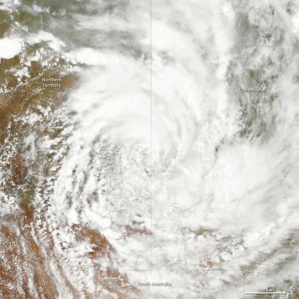
Cyclone Yasi Seen From Space

Two days after coming ashore over Queensland, Australia, the former Tropical Cyclone Yasi was still a formidable storm.
On Feb. 4, 2011, when NASA's Aqua satellite took this image, the storm still had the spiral shape characteristic of large tropical cyclones, even though it had been moving inland over mountains and desert.
Yasi made landfall as a Category 5 storm , similar to the intensity of Hurricane Andrew, which destroyed parts of South Florida in 1992. Yasi hit the coast just after midnight on Feb. 3, local time (about 9:30 a.m. EST, Feb. 2).
Yasi is bringing more rain to already soaked Queensland. The state has been battling ongoing flooding that has killed more than 20 people since December. [Related: When Will the Australia Flooding Stop? ]
The Australian Bureau of Meteorology warned residents of the Northern Territory that the storm would bring strong winds gusting up to 59 mph (95 kph) and heavy rains that may lead to flash floods. Yasi has since been downgraded from a cyclone, but was still was moving southwest at 11 mph (18 kph).
Cyclones, typhoons and hurricanes are all different names for the same weather phenomenon.
- A History of Destruction: 8 Great Hurricanes
- More Than 200,000 Affected by Flood Waters in Queensland
- The World's Weirdest Weather
Sign up for the Live Science daily newsletter now
Get the world’s most fascinating discoveries delivered straight to your inbox.


