Australia Avoids the Worst from Cyclone Yasi

Get the world’s most fascinating discoveries delivered straight to your inbox.
You are now subscribed
Your newsletter sign-up was successful
Want to add more newsletters?
Join the club
Get full access to premium articles, exclusive features and a growing list of member rewards.
As the devastation from last week's Cyclone Yasi is assessed, Australia seems to have dodged a huge bullet.
Yasi made landfall on the northeastern coast of Australia as a Category 5 storm , according to the Australian Bureau of Meteorology. Yasi, which hit the coast just after midnight Feb. 3 local time (about 9:30 a.m. EST, Feb. 2), has been blamed for only one death so far. It also has added to Queensland's flooding woes, but not as much as one scientist feared. [Related: When Will the Australia Flooding Stop? ]
"Australia was lucky in that Yasi hit a relatively unoccupied section of coast," said Australian-born atmospheric scientist Greg Holland, of the University Corporation for Atmospheric Research in Boulder, Colo.
Article continues belowHad the storm hit a major population center, the devastation would have been immense, said Holland.
Yasi was the most intense cyclone to hit the east coast of Australia on record. (Cyclones, typhoons and hurricanes are different names for the same weather phenomenon.) The cyclone had sustained winds of up to 155 mph (250 kph), according to NASA satellite measurements.
Had a similar storm hit a major center in the United States, the damage would likely have reached record levels, Holland said.
"Nowhere on Earth can withstand a Cat 5 hurricane without substantial damage," Holland told OurAmazingPlanet.
Get the world’s most fascinating discoveries delivered straight to your inbox.
Australia was damaged, to be sure. Yasi made landfall near Mission Beach, home to about 500 people, and Cardwell, home to about 1,200. As Yasi roared inland, it ripped roofs off houses and flung cars and boats through the air. The storm destroyed 150 homes and damaged 650 others, Radio Australia reported.
Yasi also brought more rain to Queensland, which has been battling ongoing flooding that has killed more than 20 people since December.
"Yasi added to the overall flooding difficulties in northern Queensland, but not as much as I feared," Holland said.
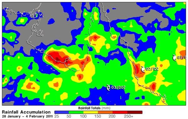
Most of central Queensland got about 2 to 4 inches (50 to 100 millimeters) of rain, according to a NASA satellite. Yasi streaked across the region, leaving little time for the rain to accumulate. The northeast coastal regions of Queensland received slightly more rain, about 4 to 6 inches (100 to 150 mm).
The tail of Yasi brought moist air over south Victoria, where it collided with a large cold front heading north. That collision, along with moisture remaining from Cyclone Anthony at the end of January, created huge cloudbursts that dumped up to 7.8 inches (200 mm) of rain in just two hours over Melbourne and regional Victoria, reported the Sydney Morning Herald. Low-lying areas of Melbourne's central business district have gone under water.
- A History of Destruction: 8 Great Hurricanes
- More Than 200,000 Affected by Flood Waters in Queensland
- The World's Weirdest Weather
Reach OurAmazingPlanet staff writer Brett Israel at bisrael@techmedianetwork.com. Follow him on Twitter @btisrael.
 Live Science Plus


