California Puts Earthquake Fault Maps Online

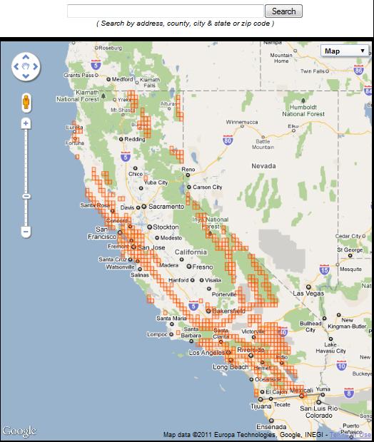
In an effort to protect lives and homes, California has published an online map of all the state's major faults that could rupture the Earth's surface during an earthquake.
California has been required by state law to map the known active surface faults since the 1970s. Those maps number in the hundreds and were cumbersome to search before they were digitized. Now that they are online, anyone can search an address with a little help from Google Maps to see if it's within an earthquake surface fault zone.
"Up until now, the issue for people wanting to use the maps has been determining which one of the 547 maps we've produced suits their needs. We've employed Google Maps address-matching technology to solve that problem," said John Parrish, of the California Geological Survey in Sacramento, in a statement.
Also under state law, home sellers are required to disclose whether their home is in a fault zone. These earthquake laws were enacted after a magnitude-6.6 earthquake struck the San Fernando Valley in 1971. Surface ruptures during that quake devastated California.
Only faults that have ruptured the ground in the past 11,000 years are considered active and are included in the maps, said Bill Bryant, senior engineering geologist at the California Geological Survey. The faults also must be well-defined enough to be detected at or near the surface by a state geologist.
The maps include the San Andreas, San Jacinto, Calaveras and Hayward faults.
A fault is a fracture or group of closely associated fractures in the crust of the Earth along which rocks on one side have moved relative to those on the other side. These major faults in California could affect 36 counties and 104 cities, so geologists have tried to make the site as user-friendly as possible.
Sign up for the Live Science daily newsletter now
Get the world’s most fascinating discoveries delivered straight to your inbox.
"The ability to read a map varies greatly," Bryant said. After 30 years as a geologist, reading a map has become second nature to him, Bryant said, but to someone looking at these maps for the first time they can seem like bunch of squiggly lines. "What really was a big help was the Google map," Bryant told OurAmazingPlanet.
Just like searching for directions, someone can search an address and if it's in a fault zone it will be highlighted. By clicking the highlighted area, users can download an official PDF of the map. This will help with the geological investigations that are required to obtain a building permit, Bryant said.
If a developer wants to build a subdivision, say, they are usually required to build about 50 feet (15 meters) away from the fault to reduce their earthquake risk , Bryant said.
But just because structures are set back from a fault, they can still be damaged when the ground shakes or by landslides, Bryant said.
The earthquake fault zone map is online at http://www.quake.ca.gov/gmaps/ap/ap_maps.htm
- Massive Chile Quake May Have Set Off California Shaking
- 7 Ways the Earth Changes in the Blink of an Eye
- Eyewitnesses Watched as China Earthquake Ripped Ground
Reach OurAmazingPlanet staff writer Brett Israel at bisrael@techmedianetwork.com. Follow him on Twitter @btisrael.


