Recent Nevada Earthquake Swarm Mapped

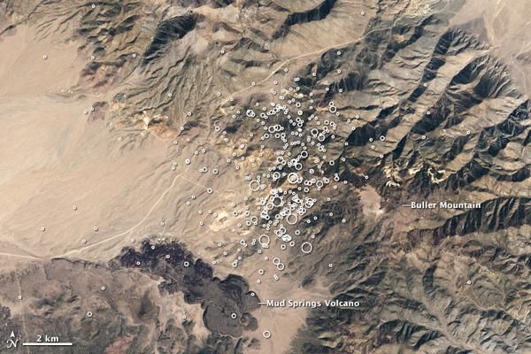
For the past several weeks, a swarm of earthquakes has shaken the ground near Hawthorne, Nevada, according to a NASA statement. The small- and medium-sized earthquakes are concentrated near Buller Mountain, in an area of about 10 square kilometers (4 square miles). Over 400 earthquakes above magnitude 1.0 have occurred in the area since April 10, up to a magnitude of 4.6.
This map shows earthquake locations (white circles) from March 5, 2011, through the early morning of April 27, superimposed on a natural-color satellite image from September 19, 2002. At low elevations the lightly vegetated land is tan, while the Wassuk Range is covered in dark green forest. Several abandoned mines in the area are visible as bright scars on the landscape, and the lava flows of Mud Springs Volcano are dark gray. The image was acquired by the Enhanced Thematic Mapper Plus (ETM+) aboard Landsat 7.
Although the earthquake swarm is adjacent to the Aurora-Bodie Volcanic Field, the earthquakes are tectonic in origin, not volcanic, and do not signal an impending eruption . Geologists distinguish between tectonic and volcanic earthquakes by looking at the waveforms recorded by seismographs. High-frequency events with a sharp onsetlike a drum beatare tectonic. Earthquakes that are long lasting and low- or medium-frequencylike a sustained noteare likely to be volcanic.
The Hawthorne earthquake swarm is located in the Basin and Range geologic province. The Basin and Range is an area of flat, low elevation valleys situated between linear mountain ranges, that stretches from the Sierra Nevada in the west to central Utah in the east. This complex topography is caused by uplift, stretching, and thinning of the North American crust. The stretching crust results in the frequent earthquakes and occasional volcanism in the area.
Sign up for the Live Science daily newsletter now
Get the world’s most fascinating discoveries delivered straight to your inbox.


