NASA Mission Probes Clouds' Rainmaking Secrets

Why do some clouds produce lots of rain, while others do not? By flying an aircraft into rain clouds, NASA scientists are on a mission to find out.
The mission will reveal the inner workings of rainmaking clouds and is unprecedented in scope, said mission team members. Scientists will combine data gathered by instruments on the ground with measurements taken by high-tech instruments installed on aircraft flying above and into rain clouds. The data should further the team's goal of forecasting and measuring rainfall from satellites.
"Because precipitation is so critical to our daily existence, we naturally would like to know how much rain falls at any given place and time," said Walt Petersen, a scientist at the NASA Marshall Space Flight Center in Huntsville, Ala., who is leading NASA's part of the campaign. "Our goal is to observe and measure the entire precipitation process, from the ice that forms near the tops of clouds to the rainfall that ends up on the ground."
The mission, called Midlatitude Continental Convective Clouds Experiment (MC3E),began on April 22 and runs to June 6.
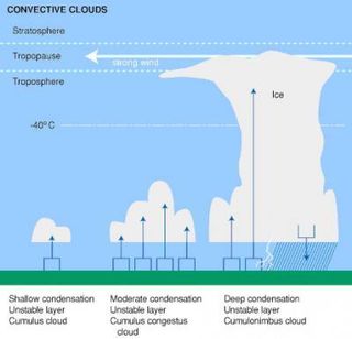
The mission is focusing on convective clouds, which form when warm, moist air rises and condenses at higher altitudes. Cumulus and cumulonimbus clouds (also known as thunderclouds) are types of convective clouds.

Storm clouds should be plentiful during the campaign. The mission is under way during severe weather season and is based near Ponca City in central Oklahoma, in the middle of Tornado Alley.
Researchers will observe clouds from high altitudes using instruments installed on NASA's ER-2 aircraft, while sampling the sizes, types and shapes of precipitation from aircraft flying at lower altitudes within the cloud. Meanwhile, ground-based radars and imaging networks are analyzing the precipitation that actually falls to the ground.
Sign up for the Live Science daily newsletter now
Get the world’s most fascinating discoveries delivered straight to your inbox.
Convective clouds are most common in the tropics, but are also common at higher latitudes, including Oklahoma, and appear as puffs, mounds or towering clouds that can range from as low as 1,000 feet to more than 50,000 feet (305 meters to 1,500 meters) in altitude. In these clouds, large amounts of water vapor are cooled and condensed into water droplets and eventually fall as precipitation. The amount of rain that falls can vary based on the type of cloud and other processes that the scientists are hoping to better understand.
"Convective cloud processes play a critical role in our daily lives," said study team member Michael Jensen, a meteorologist with the Department of Defense. "To represent these cloud systems in computer models of the atmosphere, we need to understand the details of why these clouds form, where they form, how they grow and shrink, and what factors control the amount of rain that falls from them.MC3E will provide insights into all of these questions."
- Image Gallery: Reading the Clouds


