La Niña Weakening, Effects Could Linger

The 2011 Atlantic Hurricane Season Outlook could be an above-normal year for activity, according to the forecast from the U.S. National Oceanic and Atmospheric Administration.
This hurricane season may see 12 to 18 named storms and six to 10 hurricanes, according to the forecast .
Several climate factors will play a role in this year's hurricane season, including warm Atlantic Ocean water, where sea surface temperatures in areas where storms often develop and move across the Atlantic are up to 2 degrees Fahrenheit (1.1 degrees Celsius) warmer than average, according to NOAA.
An ocean-atmosphere phenomenon called La Niña, which results in a cooling of the equatorial Pacific Ocean, has been linked to an increase in hurricane activity for the continental United States and the Caribbean. And though it continues to weaken and is expected to dissipate later this month or in June, its impacts are expected to continue into the hurricane season, according to forecasters.
During La Niña years, wind shear is reduced in the Tropical Atlantic, creating conditions that are ideal for tropical cyclone formation (tropical cyclone is the generic name for tropical storms and hurricanes) .
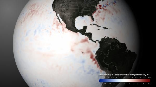
This image shows how the sea surface temperatures have changed, on average, from mid-April to mid-May. A warming signature is clearly visible as indicated by the red areas in the Eastern Equatorial Pacific region, an indication of La Niña's waning strength. Also related to the Atlantic Hurricane Season, warming trends are visible in the Caribbean and Eastern Gulf of Mexico.
- A History of Destruction: 8 Great Hurricanes
- Natural Disasters: Top 10 U.S. Threats
- The World's Weirdest Weather
Sign up for the Live Science daily newsletter now
Get the world’s most fascinating discoveries delivered straight to your inbox.


