Existing Satellites Could Help Track New Hurricanes
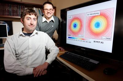
One of the scariest things about tropical storms is that they can intensify into major hurricanes with little or no warning. But satellites already orbiting Earth could help sound the alarm sooner, according to a new study.
Meteorologists showed that existing satellites could monitor tropical storms and predict sudden surges in strength. These high-tech watchdogs could lead to better warnings for coastal residents and oil rig workers when a storm headed in their direction is becoming a hurricane. [Related: Hurricane Season Forecast to Be Above Average ]
"It's a really critical piece of information that's really going to help society in coastal areas, not only in the U.S., but also globally," said study team member Stephen Nesbitt, an atmospheric scientist at the University of Illinois in Champaign.
Forecasting the path of tropical storms and hurricanes remains an elusive goal. One of the biggest problems meteorologists face is determining when storms will suddenly transform into much stronger cyclones or hurricanes. A moderate-strength tropical storm can escalate in less than 24 hours to a Category 2 or 3 hurricane, according to study team member Daniel Harnos.
Hurricane Charley, which hit southern Florida in 2004, is one tragic example. The storm was initially forecast as a Category 1 storm. When it made landfall less than 24 hours later, it had strengthened to a Category 4, causing major damage.
This intensification is so difficult to predict because it's driven by the inner workings of a storm system, rather than the better-predicted, large-scale winds that determine the direction of the storms. The satellite imagery most commonly used for meteorology only looks at the clouds at the top of the storms, giving little insight as to what's going on inside the system.
"It's somewhat like trying to diagnose somebody with a broken arm by taking a picture of the arm, versus being able to X-ray it," Nesbitt said.
Sign up for the Live Science daily newsletter now
Get the world’s most fascinating discoveries delivered straight to your inbox.
The new study shows how satellites that are used commonly for estimating precipitation, surface temperature and other data, can see inside the storms, by sensing the amount of ice within the clouds.
The researchers scoured data from passive microwave satellites from 1987 to 2008 to see how hurricanes behaved in the 24 hours before a storm underwent rapid intensification. Such storms showed a different structure when intensifying: They form a large, bull's-eye thunderstorm in the center of the system, rather than a ring around the center.
"Now we have an observational tool that uses existing data that can set off a red flag for forecasters, so that when they see this convective ring feature, there's a high probability that a storm may undergo rapid intensification," Nesbitt said. "This is really the first way that we can do this in real time rather than guessing with models or statistical predictions."
The study was published in the April 15 edition of the journal Geophysical Research Letters.

