New Crater Lake Forms on Iceland Volcano

News
By
Live Science Staff
published

Add us as a preferred source on Google
Subscribe to our newsletter
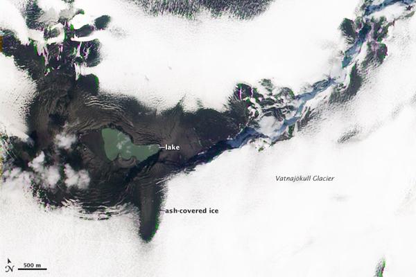
After covering a large portion of Iceland with ash in late May 2011, Grímsvötn Volcano left behind a small lake filled with melt water and a hole in the Vatnajökull Glacier. This natural-color satellite image was acquired by the Advanced Land Imager (ALI) aboard Earth Observing-1 (EO-1) on June 11, 2011.
The lake covers much of the site of the eruption, with the possible exception of the crescent-shaped feature along the southern shore of the lake. This may be a tephra cone left behind by the eruption. Gray ash covers the ice of Vatnajökull Glacier near the vent. Further away, the ash layer itself is obscured by snow.
- In Images: Spectacular Sunsets Courtesy of Chile Volcano
- The 10 Biggest Volcanic Eruptions in History
- The World's Highest Large Lake
Sign up for the Live Science daily newsletter now
Get the world’s most fascinating discoveries delivered straight to your inbox.
For the science geek in everyone, Live Science offers a fascinating window into the natural and technological world, delivering comprehensive and compelling news and analysis on everything from dinosaur discoveries, archaeological finds and amazing animals to health, innovation and wearable technology. We aim to empower and inspire our readers with the tools needed to understand the world and appreciate its everyday awe.
LATEST ARTICLES


