Atlantic's Third Tropical Storm, Cindy, Is Born

Get the world’s most fascinating discoveries delivered straight to your inbox.
You are now subscribed
Your newsletter sign-up was successful
Want to add more newsletters?
Join the club
Get full access to premium articles, exclusive features and a growing list of member rewards.
While Tropical Storm Bret is winding down, Tropical Storm Cindy has formed.
Cindy strengthened into a tropical storm today (June 20) about 665 miles (1,065 kilometers) east-northeast of Bermuda.
Cindy is the third named storm (tropical storms and hurricanes receive names) to form during the 2011 Atlantic hurricane season, which began on June 1. Tropical Storm Arlene formed in the Gulf of Mexico in late June. Tropical Storm Bret continues to move northeast, away from the United States.
Article continues belowCindy has maximum sustained winds of 40 mph (65 kph) and is moving northeast at 24 mph (39 kph). Cindy is expected to keep moving in this direction over the next few days, according to the National Hurricane Center. There are no coastal watches or warnings in effect and the center of the storm is expected to remain far from land.
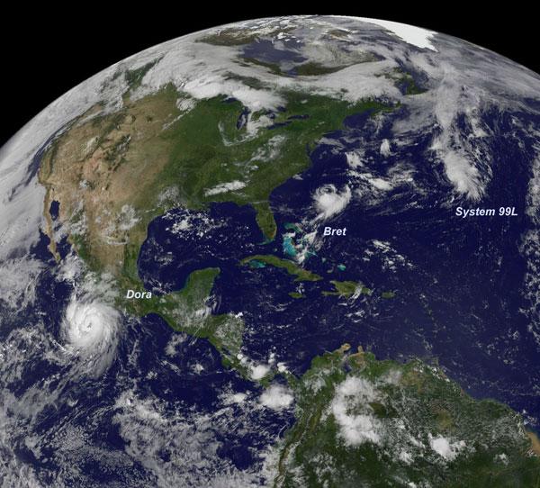
NASA's GOES-13 satellite captured an image of the two Atlantic storms, plus Hurricane Dora in the Pacific Ocean. The visible image was taken on July 20 at 10:45 a.m. EDT and shows a consolidating low pressure area called System 99L, which later became Tropical Storm Cindy, in the eastern North Atlantic Ocean. Tropical Storm Bret is seen several hundred miles east of South Carolina, and a large Hurricane Dora sits off the west coast of Mexico.
Despite the slow start, the 2011 Atlantic hurricane season has been predicted to be a doozy. The U.S. National Oceanic and Atmospheric Administration (NOAA) has predicted between six to 10 hurricanes, three to six major hurricanes (those with winds of 111 mph (179 kph) or higher) and 12 to 18 named storms.
There have been no hurricanes yet in the Atlantic basin this year.
Get the world’s most fascinating discoveries delivered straight to your inbox.
 Live Science Plus


