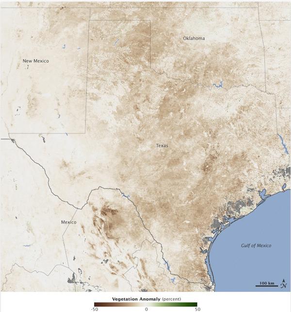
Satellite Sees Effects of Disastrous Texas Drought

Get the world’s most fascinating discoveries delivered straight to your inbox.
You are now subscribed
Your newsletter sign-up was successful
Want to add more newsletters?
Join the club
Get full access to premium articles, exclusive features and a growing list of member rewards.
By mid-July, Texas and New Mexico had completed the driest six-month period on record.
Average rain between January and June was more than 8 inches (203 millimeters) below average in Texas and 3.5 inches (89 millimeters) below average in New Mexico. Record warm temperatures also persisted in Texas between April and June. Lack of rain and warm temperatures added up to exceptional drought.
This image shows the impact of drought on plants throughout Texas, New Mexico and Oklahoma. Made with data from the Moderate Resolution Imaging Spectroradiometer (MODIS) on NASA's Terra satellite, the image compares plant growth between June 26 and July 11, with average conditions for the period. The image is dominated by brown, showing that plants were growing less than average throughout Texas and New Mexico.
Article continues belowThe image supports an assessment by the U.S. Drought Monitor, which states that 94 percent of the range and pastureland in Texas was in poor or very poor condition in June. In Oklahoma, 78 percent of range and pastureland was in poor condition.
Though drought is not a disaster that strikes all at once, working rapid destruction , it is nonetheless a devastating event that can cause death, disease, and loss of money and property. For these reasons, drought is termed the creeping disaster.
So far, farmers in Texas have lost 30 percent or more of their crops and pasture in 2011. The loss led the U.S. Department of Agriculture to declare a natural disaster in 213 Texas counties and additional counties in Arkansas, Louisiana, New Mexico and Oklahoma. The declaration qualifies farmers in these regions for low-interest loans to cover their losses.
The drought conditions have also helped to fuel forest fires, including some of the worst wildfires in the state's history .
Get the world’s most fascinating discoveries delivered straight to your inbox.
 Live Science Plus


