Fernanda and Greg in Pacific 'Chase'
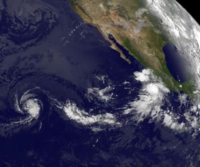
The Eastern Pacific Ocean is fired up with two tropical storms today, Fernanda and Greg, and both were caught in one image from the GOES-11 satellite. Both appear to be chasing each other to the west, and Fernanda appears a little more organized in satellite imagery and stronger than her "little brother."
The newest tropical storm, Greg, formed this morning, August 17 off the west coast of Mexico from a low previously known as System 99E. Greg is about 135 miles (220 km) south-southwest of Zihuatanejo, Mexico. Because Greg is close to the western coast of Mexico, the National Hurricane Center noted that heavy rainfall is possible in the next day or two along the coasts of two Mexican states: Guerrero and Michoacan.
The Geostationary Operational Environmental Satellite called GOES-11 caught an image of eastern Pacific on August 17 at 1200 UTC (8 a.m. EDT) and showed Fernanda moving into the Central Pacific Ocean while Greg is in the far Eastern Pacific. The image was created at NASA's GOES Project, located at NASA Goddard Space Flight Center in Greenbelt, Md. NOAA manages the GOES-11 satellite and NASA uses its data to create images and animations.
In the image, Fernanda far west of Greg, has a signature shape of a mature tropical storm, while Greg shows high clouds and powerful convection and thunderstorms in the center of circulation, but had not yet fully developed the signature comma shape. The eastern quadrant of Greg's clouds extended over the southwestern Mexico coastline, and his thunderstorms were dropping moderate to heavy rainfall.
On August 17 at 5 a.m. EDT (0900 UTC), Tropical Storm Greg's maximum sustained winds were near 40 mph. Those tropical storm-force winds extend outward up to 45 miles, making the storm 90 miles in diameter. Estimated minimum central pressure is 1004 millibars. Greg was centered near 15.8 North and 102.2 West and moving to the west-northwest near 16 mph (26 kmh). Greg's center is expected to remain well offshore from the southwestern Mexico coastline.
Greg is located in a decent environment for strengthening: moist air, moderate wind shear from the northeast and warm sea surface temperatures near 86 Fahrenheit (30 Celsius). It takes sea surface temperatures of at least 80F (26.6C) to support a tropical cyclone.
Tropical Storm Fernanda is stronger than her "little brother" Greg, with maximum sustained winds near 50 mph (85 kmh) and some slight strengthening is still possible, according to the National Hurricane Center. Greg is not only Fernanda's "little" brother in terms of winds but also in terms of extent of tropical storm-force winds. Fernanda's tropical storm-force winds extend out 70 miles from the center making her 50 miles wider in diameter than Greg.
Sign up for the Live Science daily newsletter now
Get the world’s most fascinating discoveries delivered straight to your inbox.
On August 17 at 5 a.m. EDT, Fernanda was still very far from Hawaii. In fact, she was centered about 1,350 miles (2, 715 km) east-southeast of South Point, Hawaii near 11.6 North and 136.9 West. She's moving to the west near 7 mph (11 kmh) and is expected to turn to the west-northwest over the next couple of days. Fernanda is not expected to reach hurricane status as she continues to move west and Greg continues to chase her.

