Tropical Storm Katia Is Born
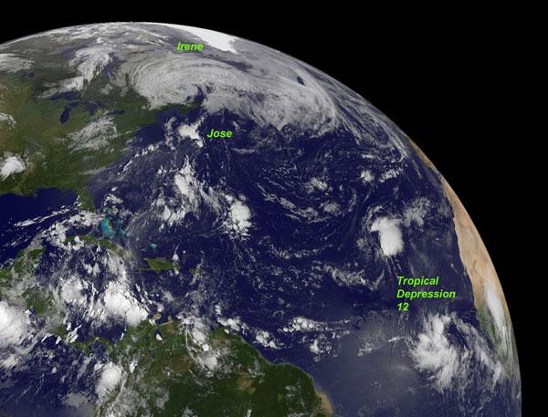
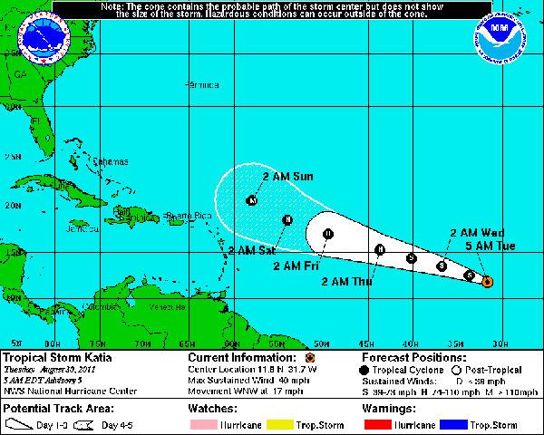
During the night of Aug. 29-30, Tropical Depression 12 became Tropical Storm Katia, with winds of 40 mph (65 kph).
Katia is the 11th named storm of the 2011 hurricane season (tropical storms and hurricane receive names), and is poised to become the second hurricane of the season. The name Katia replaced Katrina on the hurricane name list after Katrina was retired.
The burgeoning storm is not expected to threaten land any time soon; its current position is 535 miles (855 kilometers) west-southwest of the Cape Verde Islands. The storm is expected to continue in this direction as it strengthens in the coming days. It's too soon to tell whether the storm will eventually threaten the United States. [Which U.S. Cities Are Most Vulnerable to Hurricanes?]
The GOES-13 satellite took the above image of Katia while it was still Tropical Depression 12, along with the remnants of Irene raining over Newfoundland and Tropical Storm Jose dissipating in the North Atlantic.
Meterologists with AccuWeather are also watching a system in the Gulf that could become Tropical Storm Lee by the end of Labor Day weekend.
The 2011 hurricane season has been predicted to be a doozy. The National Oceanic and Atmospheric Administration updated its forecast on Aug. 4, predicting 14 to 19 named storms (which include tropical storms and hurricanes), seven to 10 hurricanes and three to five major hurricanes. An average Atlantic hurricane season will see 11 named storms, six hurricanes and two major hurricanes. August through October are the peak months of the Atlantic hurricane season.
- Hurricanes from Above: See Nature's Biggest Storms
- Infographic: Storm Season! How, When & Where Hurricanes Form
- Storm Targets: Where the Hurricanes Hit
Sign up for the Live Science daily newsletter now
Get the world’s most fascinating discoveries delivered straight to your inbox.


