India Quake Likely the Fault of 2 Seismic Events
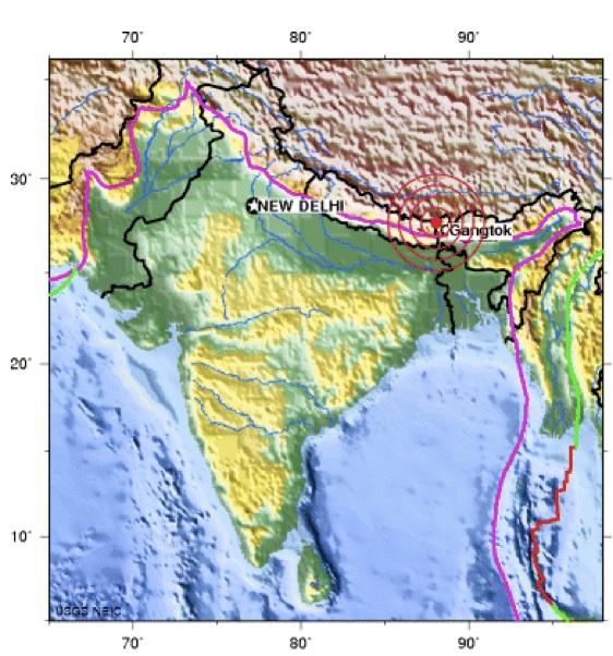
India's earthquake yesterday (Sept. 18) was likely the result of two seismic events striking at nearly the same time, according to the U.S. Geological Survey (USGS).
The magnitude 6.9 quake killed at least 55 people in northeastern India, Nepal and Tibet, reported the Associated Press. The quake rumbled the mountainous region of the Indian town of Mangan, in the northeast Indian province of Sikkim, and near the Nepalese border.The epicenter was 42 miles (68 kilometers) northwest of Gangtok, India. Tremors from India's big earthquake were felt as far away as Bangladesh and New Delhi.
The quake came at the end of the monsoon season, and rain-soaked hills spawned landslides that caused much of the devastation, according to the American Geophysical Union's Landslide Blog. Heavy rainfall and more aftershocks in the coming days could complicate recovery efforts.
A flurry of big earthquakes have hit in recent weeks around the seismically and volcanically active Pacific Ring of Fire , but they were not triggered by each other.
The Sikkim earthquake, as it's called, was also unrelated to these other temblors, but was seismically complex in its own right. The quake was likely a result of two seismic events occurring close together in time at depths of approximately 12.4 miles (20 km) beneath the Earth's surface, the USGS told OurAmazingPlanet.
The quake struck near the boundary between the India and Eurasia tectonic plates, which are huge slabs of the Earth's crust that mash and grind together and trigger earthquakes. Here, the India plate converges with Eurasia at a rate of approximately 46 millimeters per year toward the north-northeast. Over millions of years, this convergence created the uplift of the Himalayas, the world's highest mountain range .
The initial analysis of the earthquake suggests the quake wasn't caused by one plate thrusting beneath another, but by so-called strike-slip faulting, a mechanism where fault systems slide side-to-side when two tectonic plates butt heads.Geologists suspect the fault is likely an intraplate fault within the upper Eurasian plate or the underlying India plate, rather than occurring at the interface between the two plates, according to the USGS.
Sign up for the Live Science daily newsletter now
Get the world’s most fascinating discoveries delivered straight to your inbox.
Geophysicists' best guess is that the quake was actually two strike slip events, one immediately after the other, so that it registered as one quake. But scientists may not ever know for sure since closely spaced events are tough to tease apart, said Paul Caruso of the USGS.
This mountainous region has seen moderately sized quakes in the past, with 18 earthquakes of magnitude 5 or greater over the past 35 years within 61 miles (100 km) of the epicenter of the Sept. 18 quake. The largest of these was a magnitude 6.1 earthquake in November 1980, 47 miles (75 km) to the southeast of the epicenter.
- 7 Most Dangerous Places on Earth
- Image Gallery: This Millennium's Destructive Earthquakes
- The 10 Biggest Earthquakes in History
Follow OurAmazingPlanet for the latest in Earth science and exploration news on Twitter @OAPlanet and on Facebook.


