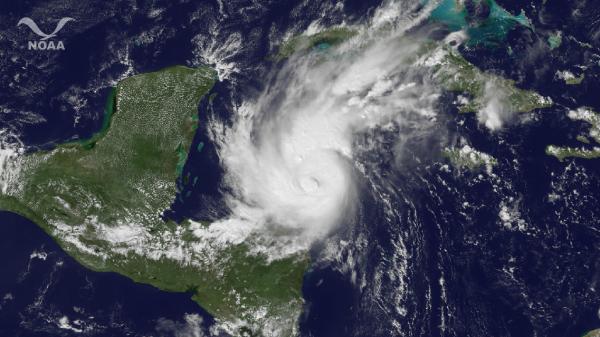
Hurricane Rina Strengthens to Category 2 Storm

Hurricane Rina has strengthened to a Category 2 storm, and could become a major hurricane tonight or early tomorrow (Oct. 26).
Rina is the sixth of the 2011 Atlantic hurricane season.
Rina formed over the northwest Caribbean Sea, and is currently about 215 miles (345 kilometers) southwest of Grand Cayman and 305 miles (490 kilometers) of Chetumal, Mexico. The storm has winds of 100 mph (161 kph) is heading toward the Yucatan Peninsula of Mexico. A hurricane watch is in effect for the Yucatan's east coast. The center of the storm could reach the coast by Thursday (Oct. 27).
Rina is the 17th named storm of the 2011 season (storms receive names when they reach tropical storm or hurricane status).
The 2011 season was predicted to be a doozy, with 14 to 19 named storms (which include tropical storms and hurricanes), seven to 10 hurricanes and three to five major hurricanes (Category 3 or higher).
The most recent storm before Rina was Phillipe (the letter Q is skipped in the hurricane name list), which first formed in September and churned across the Atlantic for two weeks before becoming a hurricane on Oct. 6. It weakened shortly thereafter and the waters of the Atlantic, Gulf of Mexico and Caribbean were relatively quiet for most of October.
There is about one month left in the traditional Atlantic hurricane season, which begins each year on June 1 and ends on Nov. 30.
Get the world’s most fascinating discoveries delivered straight to your inbox.

